Using images in Geography #1 Identify, classify, rank and justify
Images are a great way of encouraging thinking skills in the geography classroom. This series of posts explores a range of strategies to support the development of thinking through the use of images.
Using images in Geography #1 Identify, classify, rank and justify
Identify, classify, rank and justify is a technique that can be used to explore the impact of a range of human and physical manifestations such as earthquakes, hurricanes, volcanic eruptions, deforestation and climate change. Using this technique involves sharing a collection of images that illustrate the primary and secondary impacts of an occurrence such as an earthquake along with human responses to it. An example is shown below.
First of all, learners identify the cause and impacts of the earthquake. This encourages them to consider what caused the problem and the different types of impacts this can cause. It is a useful way of introducing new information to learners (rather than just telling them!). It is useful to get feedback from students via targeted questioning to check understanding and overcome misconceptions.
Next, the learners then classify the impacts by attempting to group them. Learners can sometimes come up with some weird and wonderful groupings so it is worth checking learning by circulating and questioning. Lower attaining students may need a prompt to support them e.g. group the impacts into primary and secondary effects. The learners then have to identify a grouping for those images left over. In the case above this would be responses to the earthquake.
Learners then rank the primary and secondary effects according to their impact. They should then be encouraged to discuss these rankings in pairs to help consolidate their understanding and begin to give reasons for their choices.
Finally, they then produce a piece of extended writing to justify their views. This helps support students develop their ability to tackle higher order thinking questions.
I’ve found this technique works really well in my classroom with my students. If you have a go please let me know how it went.
If you use images in a way that has a positive impact on learning please use the contact form to get in touch!
Anthony Bennett
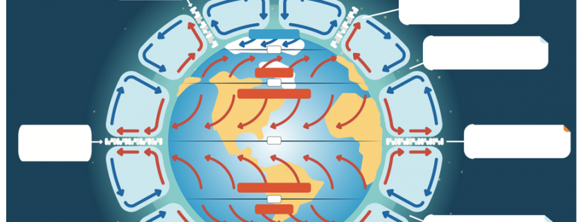
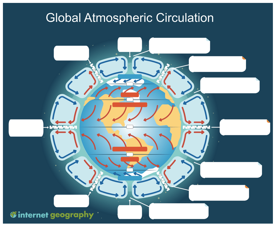
Using Images in Geography #4 Diagrams from memory
Diagrams from memory are a great way to revisit prior learning. In this case, we’re sharing an unlabelled diagram of the global atmospheric circulation diagram. The idea is to display the labelled diagram for a short period of time to remind students of the key components of global atmospheric circulation. A simple quiz could be used to encourage the students to think about the features of the model and the processes that drive global atmospheric circulation. Following this, any misconceptions can be addressed before removing the labelled image from display.
Students then complete the blank diagram to demonstrate what they know. Scaffolding can be provided to the students who need it through providing additional annotations or the first letter of each label.
Found this useful? Take out a subscription to Internet Geography Plus to support further developments on the site.
Click the image below to download the template.

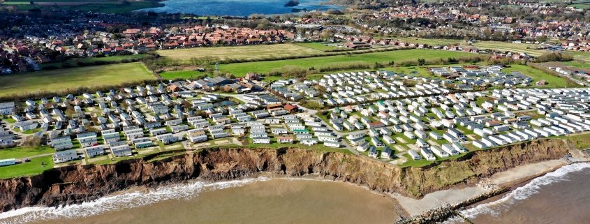
Using Images in Geography #3 Thinking like a geographer
Increasingly students are being expected to ‘think like a geographer’ by applying skills, knowledge and understanding to unfamiliar contexts.
The use of photographs and question stems is a useful way of encouraging students to ‘think like a geographer’. After all, students have to learn how to ask questions to be able to apply themselves to unfamiliar contexts.
Before this can be done, students need to have a basic understanding of what geography is, and this post is based on the premise that they have an awareness of the main geographical concepts your curriculum is based on.
The first step in achieving this might be to introduce the concept of using images to think like a geographer. Modelling how a geographer might use a photograph to consider the geography of a particular location to demonstrate the process through thinking aloud would provide cognitive strategies that students could adopt. Thinking aloud by the teacher will provide students with a way to witness expert thinking, usually hidden from them.
The next step in encouraging students to think like a geographer could be to provide scaffolding and model geographical questions using images.
General question stems, applicable to most geographical photographs, could be introduced to less experienced students of geography. Examples could include:
- What are the main geographic features shown in the picture?
- What are the human features of _____________?
- What are the physical features of ___________?
- How are the physical and human features of __________ linked?
- What are the strengths and weaknesses of _______________?
- How does ________________ affect ________________?
- How does ________________ link to ________________?
- How does the location compare to __________________?
- What processes cause ________________________?
- How would changing ____________________ affect ____________________?
- How is this _________ interdepedent?
- What issues relating to sustainability affect ____________?
- How does __________________ link to what you have studied in geography in the past?
- What do you not understand about _______________________?
- In what way is _____________ related to _______________?
Alternatively, you could use more concrete prompts to encourage students to think like a geographer. Examples include:
- Identify the geographical concepts evident in this image
- Write a sentence/paragraph to reflect what is shown in this image
- Use these words as a prompt to figure out the main geographical issues evident in this image.
- Select two details that elaborate on the main geographical issues in this area and are important to remember
- How might changes in this area have a positive/negative impact?
- Describe and explain the issues of sustainability in this image.
- Explain the potential impact of climate change on this area.
- What are the human and physical processes in this area and how do they interact?
As students become more experienced asking geographical questions, the teacher could then move onto providing students with prompts such as who, what, when where, why and how before removing the scaffolding completely. Of course, this can be done at any time that is appropriate for individual students.
As students are analysing the photograph it is a good opportunity for the teacher to circulate and check and challenge student thinking. Providing hints, prompts, suggestions, and feedback when students encounter difficulties is encouraged at this stage.
Following this, targetted questioning is a useful way to check understanding and address misconceptions that students might have.
Anthony Bennett
Related posts:
Using Images in Geography #1 Identify, classify, rank and justify
Using Images in Geography #2 Scroll it
Further reading
The Use of Scaffolds for Teaching Higher-Level Cognitive Strategies


Leave a Reply
Want to join the discussion?Feel free to contribute!