We’ve compiled a PDF file you can share with students containing QR codes and short URLs so they can get straight to the area they want to revise. Just click the image below to download.
According to data from the United Nations, India is on track to surpass China as the world’s most populous country by June 2023. India’s population is projected to reach 1.4286 billion, approximately 2.9 million more than China’s 1.4257 billion. The two Asian countries have represented over a third of the global population for over seven decades.
China’s birth rate has recently plummeted, decreasing its population last year for the first time since 1961. The United Nations Population Fund (UNFPA) State of World Population Report’s forecast for India is estimated, as no census has been conducted in the country since 2011. The 2021 census was cancelled due to Covid and rescheduled for 2022, but it has now been postponed again to 2024.
The UN’s Chief of Population Estimates and Projection, Patrick Gerland, said that any numbers regarding India’s actual population size are “naïve assumptions based on fragmentary information,” as no official data is available. Furthermore, the UN’s estimate does not account for the populations of China’s Special Administrative Regions, Hong Kong and Macau, or Taiwan, totalling over 8 million people.
In November, the global population surpassed 8 billion, but experts note that growth has slowed considerably, reaching its lowest rate since 1950.
One of the primary reasons for India’s increasing population has been the difference in fertility rates between the two countries. Historically, India has had a higher fertility rate than China, which means that, on average, Indian women have more children than their Chinese counterparts. Over the past few decades, both countries have experienced a decline in fertility rates, but India’s rate has remained higher than China’s.
China’s strict population control measures, mainly the one-child policy implemented in 1979, significantly curbing population growth. The policy was relaxed in 2015, allowing couples to have two children, but the impact of this change on China’s population growth has been limited. In contrast, India has implemented various family planning initiatives, but it has never adopted a stringent policy like China’s one-child rule. This difference in approach has contributed to India’s higher fertility rates and overall population growth.
Another critical factor in India’s population growth is its age structure. India has a relatively young population, with a median age of around 28 years, while China’s median age is approximately 38 years. This youthful population means that there are more people in their reproductive years in India, which contributes to a higher number of births and subsequent population growth.
Rural-to-urban migration has been another driving force behind India’s population growth. In search of better opportunities and higher living standards, millions of Indians have migrated from rural areas to urban centres, leading to rapid urbanization. While urbanization has also occurred in China, India’s urban population growth has been more pronounced. The increased population density in cities has contributed to higher fertility rates in urban areas, further fueling population growth.
Socio-cultural factors have also played a role in shaping the population trends of both countries. In India, there has been a preference for larger families, particularly in rural areas, where children are often seen as economic assets which can contribute to the household income. Furthermore, the preference for male children has led some families to continue having children until they have a son, contributing to higher fertility rates.
A UNFPA-commissioned survey found that most Indians believe their population is too large and fertility rates too high, with nearly two-thirds of respondents citing economic concerns related to population growth. However, demographers argue that India’s population overtaking China’s should not be seen as a concern but as a symbol of progress and development, as long as individual rights and choices are respected, as stated in the UN report.
https://www.internetgeography.net/wp-content/uploads/2023/04/Indian-children.jpg13211980Anthony Bennetthttps://www.internetgeography.net/wp-content/uploads/2024/01/Internet-Geography-Logo.pngAnthony Bennett2023-04-23 18:39:262023-04-24 10:32:41India is close to passing China to become the world’s most populous nation
In 2022, water firms in England discharged untreated sewage into rivers and seas for over 1.75 million hours.
According to data, there was an average of 825 daily sewage spills into water bodies, a 19% decrease from the year before.
However, the Environment Agency attributes this decline mainly to a drier climate rather than proactive measures taken by water companies.
While not against the law, scholars and environmental organizations argue that discharging sewage threatens public health.
During periods of heavy rainfall, water companies release sewage to alleviate the pressure on their treatment facilities.
Untreated wastewater contains human excrement, wet wipes, and sanitary items, all of which present significant hazards to local wildlife, swimmers, and others who utilise UK waterways.
Professor Jamie Woodward, a geography expert at the University of Manchester, stated that these discharges “degrade valuable ecosystems and pose a danger to public health.”
He explained that each release is “a toxic mix of various pollutants, including microplastics and pathogens.”
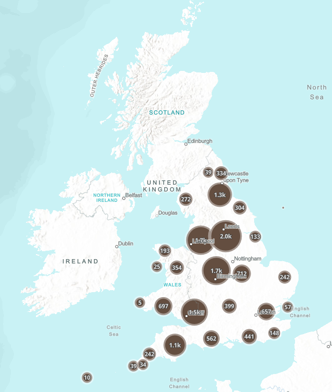
Was sewage discharged near you?
Click the map below to investigate sewage discharge near you.
Sewage discharge in England and Wales – Link to the Rivers Trust
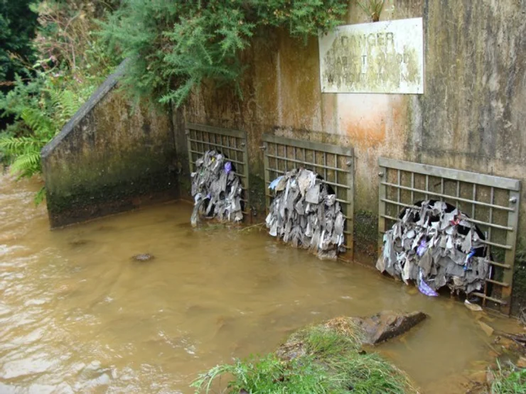
New information recently released by the Environment Agency was obtained from monitoring stations located at combined sewer overflows, or CSOs. CSOs were designed as overflow valves to minimize the likelihood of sewage backups during periods of intense rainfall, which can cause sewer pipes to become overwhelmed and result in flooding.
These valves discharge a combination of untreated sewage originating from residential and commercial properties, as well as rainwater runoff.
Although the data indicates a 34% decrease in the duration of spills since 2021, John Leyland, the Environment Agency’s executive director, stated that the reduction in the previous year was “primarily due to dry weather, not water company action.”
He further emphasized the need for accelerated progress from water companies in minimizing spills and acting on monitoring data.
The data revealed that United Utilities, servicing the North West of England, had the highest number of sewage releases in 2022. The company discharged sewage for close to half a million hours.
The Environment Agency and water regulator Ofwat is investigating six water companies for potential breach of the law over their discharges.
The government has pledged to tackle sewage spills by making water companies invest £56 billion over 25 years to enhance their infrastructure. Additionally, they must equip all storm overflows in the network with event duration monitoring (EDM) devices by the end of the current year.
Many people feel this is not enough to tackle sewage discharge in rivers and seas.
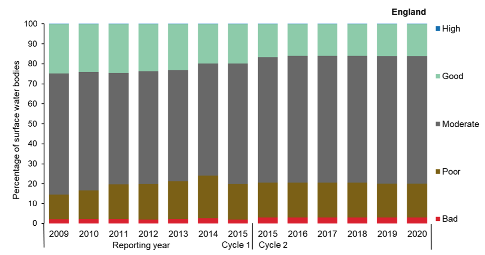
The graph below shows the status classification of surface water bodies (rivers, canals, lakes, estuaries and coastal water bodies) in England. The graph shows the percentage of water bodies with high, good, moderate, poor or bad ecological potential. A good status means a body of water has a slight variation from undisturbed conditions, meaning it is almost as it should be naturally.
There has been a decrease in the proportion of surface water bodies in England awarded high or good ecological status since the indicator was first prepared in 2009; the indicator has also declined in the short term, between 2015 and 202. In 2021, 16% of surface water bodies assessed under the Water Framework Directive (WFD) were in high or good status compared with 17% in 2015 and 25% in 2009.
https://www.internetgeography.net/wp-content/uploads/2023/04/A-combined-sewage-overflow.webp555740Anthony Bennetthttps://www.internetgeography.net/wp-content/uploads/2024/01/Internet-Geography-Logo.pngAnthony Bennett2023-04-16 17:08:432023-04-16 17:43:08Untreated Sewage and Our Rivers and Seas
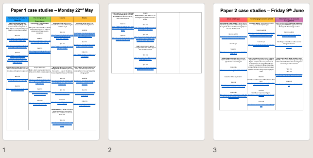
Jason Bowsley of Baysgarth School has kindly shared a useful editable document to support students with case studies and examples, including the name of case studies/examples for each section of the specification with a web link, quiz link and video link.
https://www.internetgeography.net/wp-content/uploads/2023/03/Case-studies-and-examples-with-web-links.png325644Anthony Bennetthttps://www.internetgeography.net/wp-content/uploads/2024/01/Internet-Geography-Logo.pngAnthony Bennett2023-03-27 13:06:452023-03-27 13:06:45Case Studies and Examples with Web Links
This page will be regularly updated over the coming days!
The Cayman Islands
How developed is the Cayman Islands?
The Cayman Islands is a high-income country. The graph below shows the GNI per capita for the Cayman Islands between 2010 and 2020.
Overview of the Grand Cayman cruise port proposal
The plan aimed to develop a new cruise port in George Town, Grand Cayman, to accommodate the larger Oasis-class cruise ships that cannot dock at the existing port facilities. However, there may have been new developments in the project since then.
The project faced opposition from environmentalists and some residents concerned about the potential negative impacts on the environment, particularly coral reefs and marine life. Moreover, critics argued that the increased number of tourists could strain local infrastructure and services, leading to overcrowding and a decline in the quality of life for residents.
Proponents of the project argued that the new cruise port would bring significant economic benefits to the island, including job creation, increased tourism revenue, and a boost to local businesses. They also pointed out that the design and construction of the port would include measures to mitigate environmental impacts.
In the face of the COVID-19 pandemic, the then government (People’s Progressive Movement – PPM) abandoned the proposals.
Arguments have been made for the greater diversification of tourism on the island, including the development of medical tourism. May residents were keen not to return to mass tourism through cruise ships.
The AQA GCSE Geography paper 3 pre-release will soon be available to schools. As usual, Internet Geography Plus subscribers will be able to access support materials for teaching the pre-release.
Please take a minute to complete the survey below to help us prioritise the resources we develop.
Coastal Erosion at Hemsby: A Battle Against Nature
Coastal erosion is a natural process that happens worldwide, but it has become a pressing issue for the residents of Hemsby, a village on the Norfolk coast. So, buckle up as we explore the science behind coastal erosion, how it’s impacting Hemsby, and what’s being done to fight it.
What is Coastal Erosion?
First, let’s understand what coastal erosion is all about. Coastal erosion is the wearing away of the land by the sea, often involving destructive waves wearing away the coast.
Coastal erosion is a natural process that shapes and reshapes the world’s shorelines. However, human activities, like building structures near the coast or interfering with natural habitats, can speed up erosion or worsen it.
The Hemsby Situation
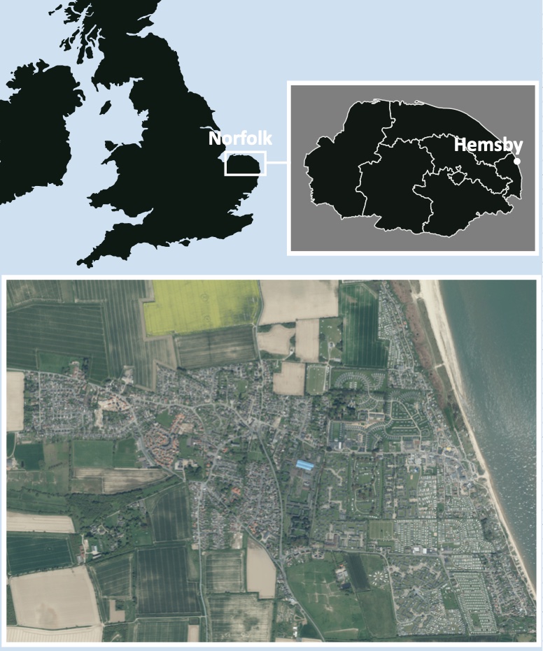
Hemsby, located on the Norfolk coast in the UK, has been struggling with coastal erosion for quite some time. The village has a beautiful stretch of sandy beach that attracts tourists and provides a livelihood for local businesses. However, the coastline has steadily disappeared, putting homes and businesses at risk.
The Location of Hemsby
The village has lost about 70 meters of coastline in the last 50 years. But the erosion has become even more severe in recent years, with storm surges and high tides causing rapid damage. In March 2018, a powerful storm known as the “Beast from the East” battered the coast, causing seven homes to fall into the sea.
The Impact on Hemsby
Coastal erosion is not just about losing land – it also affects the people living and working in Hemsby. The community’s stability is shaken as homes and businesses are threatened. Moreover, the tourism industry, a crucial part of Hemsby’s economy, could take a hit if the beautiful sandy beaches disappear. About 90% of Hemsby’s economy depends on tourism.
March 2023
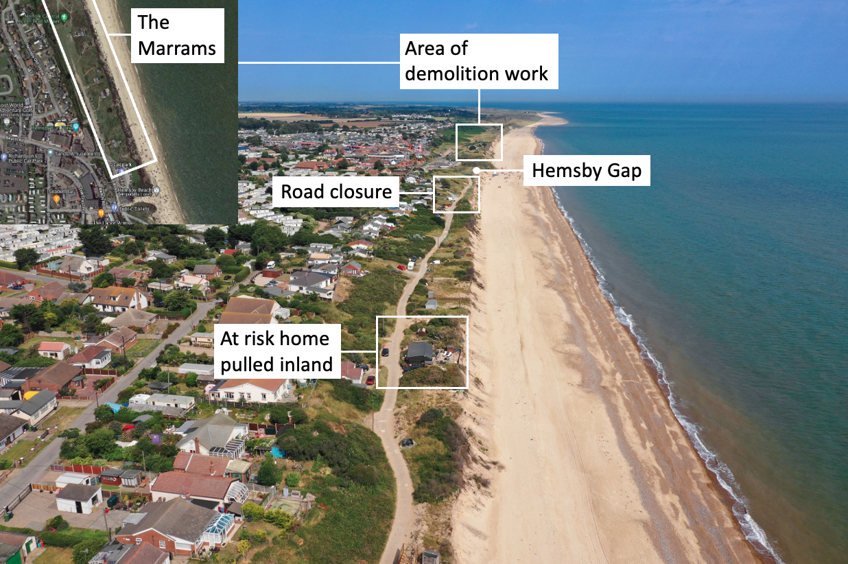
In the last few weeks, five homes have been demolished at Hemsby. Recent erosion on the coast has led to several properties built on sand dunes in the village of Hemsby, teetering on the edge and part of an access road being washed away. High spring tides (3.7m) and strong winds (50 mph) have battered the coastal stretch at The Marrams during the last two weeks.
One property was 20ft (6.1m) from the cliff edge a week before the high tides and strong winds, and then there was just 3ft (0.9m).
Demolition work by Great Yarmouth Borough Council is taking place on the north side of Hemsby Gap – a break in the dunes used by lifeboat crews to access the beach.
25th February 2023 – The beach at Hemsby was closed because of significant erosion
10th March 2023 – At-risk homes were evacuated due to fears properties could topple over the cliff. A high tide led to a playhouse and shed falling over the cliff.
11th March 2023 – The first home was demolished.
12th March 2023 – Two more homes were demolished
13th March 2023 – Two more homes were demolished.
15th March 2023 – The access road to the south of Hemsby Gap closed due to its collapse
About 2,000 tonnes of granite rock armour is being added to the beach south of Hemsby Gap as a temporary solution to protect clifftop road access to several properties. Great Yarmouth Borough Council sought permission from the landowner to put granite rocks on the beach. The granite blocks will break the waves and absorb their energy.
Hemsby Lifeboat coxswain Daniel Hurd told the BBC the current situation could have been resolved earlier.
He said: “I just think it’s absolutely ridiculous, this has been an emergency for years and it’s taken this weekend for them to see it’s an emergency to then get a rock berm put on the beach.”
The council responded saying it was a “real minefield of making sure that what local government and the authorities do is the correct line of procedure”.
Noel Galer, Great Yarmouth Borough councillor for East Flegg ward, which includes Hemsby, told Sky News people will be “trying very hard” to look after those who have lost their homes.”Some people literally have a second home which happens to be very close to the beach.
“Perhaps they knew the risks and understood the risks, accepted the risks.
“Others for various reasons may have found this is the only place they can find to live because of the cost and their circumstances and may not be so aware of what’s going on.
“They may have felt there’s no way this is ever going to be washed away.”
He said there used to be two further rows of dunes and that there is a footpath on the local map which goes out to sea.
Following the demolitions, four hundred people attended an emergency meeting in Hemsby to discuss action to help protect the village’s crumbling coastline. The Hemsby Independent Lifeboat and Save Hemsby Coastline organised the meeting. The group have started a petition to get the government to take responsibility to help save Hemsby’s coastline, residents were invited to join a protest outside Westminster or Downing Street in the future, and a “war chest” to fund legal assistance had opened.
https://www.internetgeography.net/wp-content/uploads/2023/03/Coastal-erosion-at-Hemsby.png7291098Anthony Bennetthttps://www.internetgeography.net/wp-content/uploads/2024/01/Internet-Geography-Logo.pngAnthony Bennett2023-03-19 16:07:562023-03-19 16:18:42Coastal Erosion at Hemsby: A Battle Against Nature
https://www.internetgeography.net/wp-content/uploads/2023/03/Industrial-fishing.jpg9981500Anthony Bennetthttps://www.internetgeography.net/wp-content/uploads/2024/01/Internet-Geography-Logo.pngAnthony Bennett2023-03-12 13:43:052023-12-21 00:25:33The High Seas Treaty
Environmental and climate activists are using the internet to protest against a plan to drill for oil and gas in the US state of Alaska by a company called ConocoPhillips. The leader of their country, President Joe Biden, is trying to decide if he should allow this plan to go ahead. Many people have signed a petition online to say they don’t want the plan to happen, as well as sharing messages on social media with the hashtag #StopWillow to show their support for the cause. In recent weeks, there have been 50 million direct views of #StopWillow videos on TikTok alone.
While the project has supporters and opponents in its home state, it has become a lightning rod on social media. Over the past week, TikTok users have galvanized around halting the project, with a staggering number of people watching and posting on the topic.
What is the Willow Project?
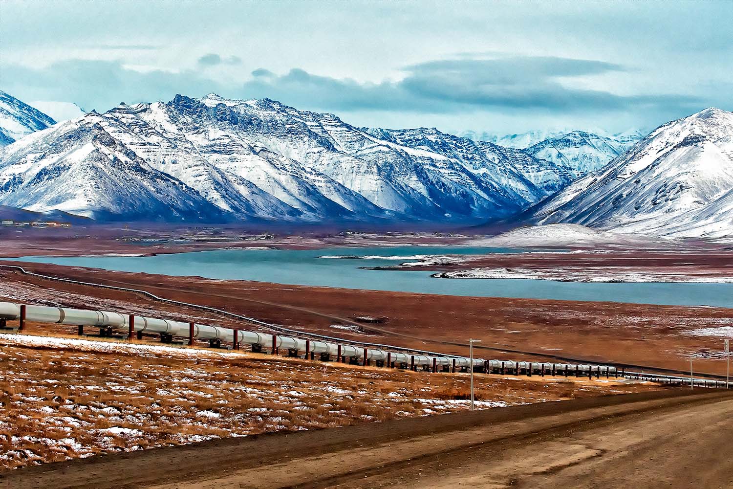
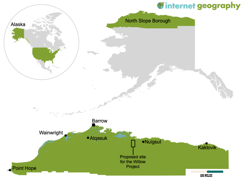
A road and oil pipeline on Alaska’s North Slope
ConocoPhillips plans to spend $6 billion to dig for oil and gas in the North Slope Borough, Alaska. The place they want to extract oil is called the National Petroleum Reserve-Alaska, a huge land area that people haven’t touched. It’s on the North Slope of Alaska, the biggest piece of untouched wilderness in the USA.
The proposed location of The Willow Project
Will the Willow Project be approved?
President Joe Biden’s team has said they will allow a smaller version of the project. The people responsible for looking after the land, the Bureau of Land Management (BLM), have looked at the plans and decided they like one option the most. This option would have fewer drill sites, a block on Arctic Ocean drilling and less surface development than the original ConocoPhillips plan. The company had wanted to dig in five different places and build many roads, seven bridges and pipes to transport the oil. A judge in Alaska had said that the original decision was not good enough because they didn’t think about the environment properly. A final decision about the project could be made soon, maybe even this month.
Why is the Willow Project important for Alaska?
The Willow project area holds an estimated 600 million barrels of oil, or more than the amount currently held in the U.S. Strategic Petroleum Reserve, the country’s emergency supply.
The project is important to Alaska’s economy. Oil production has declined in the state, which relies heavily on drilling.
ConocoPhillips said the project would deliver up to $17 billion in revenue for the national (federal) and local (state) governments and Alaska communities.
The Biden administration has also been urging U.S. oil companies to invest in boosting production to help keep the price of oil low for consumers.
Is there support for the Willow Project?
There is widespread political support in Alaska, including from those in power — Republican Governor Mike Dunleavy and state lawmakers.
There also is “majority consensus” in support in the North Slope region, said Nagruk Harcharek. He is president of the group Voice of the Arctic Iñupiat, whose members include leaders from across much of that region.
Willow’s supporters – including a coalition of Alaska Natives on the North Slope – say Willow could be a much-needed new source of revenue for the region and help fund schools, health care and other basic services. Supporters have called the project balanced and say communities would benefit from taxes generated by it. They say these would be used to invest in infrastructure and provide public services.
In recent weeks, several Alaska Native groups have also travelled to Washington for routine meetings that have often become about Willow and the state’s oil industry. Although some in the nearest town to Willow, Nuiqsut, are concerned about the project’s local impacts, many Alaska Natives stand to receive a slice of the revenue, which they say will help reduce poverty and boost generational wealth.
What is the Environmental Impact?
The BLM feel that a slimmed-down version of the project would be better for animals like polar bears and yellow-billed loons. This is because removing the most ecologically sensitive site in the project reduces the number of drilling sites from three to two. ConocoPhillips would need to shrink its development footprint by about 12 per cent to protect a yellow-billed loon nesting site and caribou migration paths.
Environmentalists are still against the project because they think it goes against what President Biden promised to do to help with climate change. They also think it would affect the land and the animals that live there through the construction of hundreds of miles of roads and pipelines carving through often pristine wilderness.
By the government’s estimates, the project would generate enough oil to release 9.2 million metric tons of planet-warming carbon pollution a year – equivalent to adding 2 million gas-powered cars to the roads. Over 30 years, climate groups have estimated it would release around 278 million metric tons of carbon pollution, which is more than 70 coal-fired power plants could produce annually.
Geography is a fascinating subject that helps us understand our world. There is much to learn from studying natural resources, climate patterns, and human geography. However, it can also be challenging, with much information to remember (most GCSE specifications have too much content!). In all honesty, I have often struggled to retain key facts and figures about geography (and other aspects of life!). My children often joke that I have a terrible memory. Having seen several posts on social media about the power of sketch notes, I decided to investigate further. Sketch notes are a visual way of taking notes that involve drawing and writing to represent information clearly and concisely. Instead of just writing down words or phrases, sketch notes use images and symbols to represent ideas, making remembering and recalling them easier.
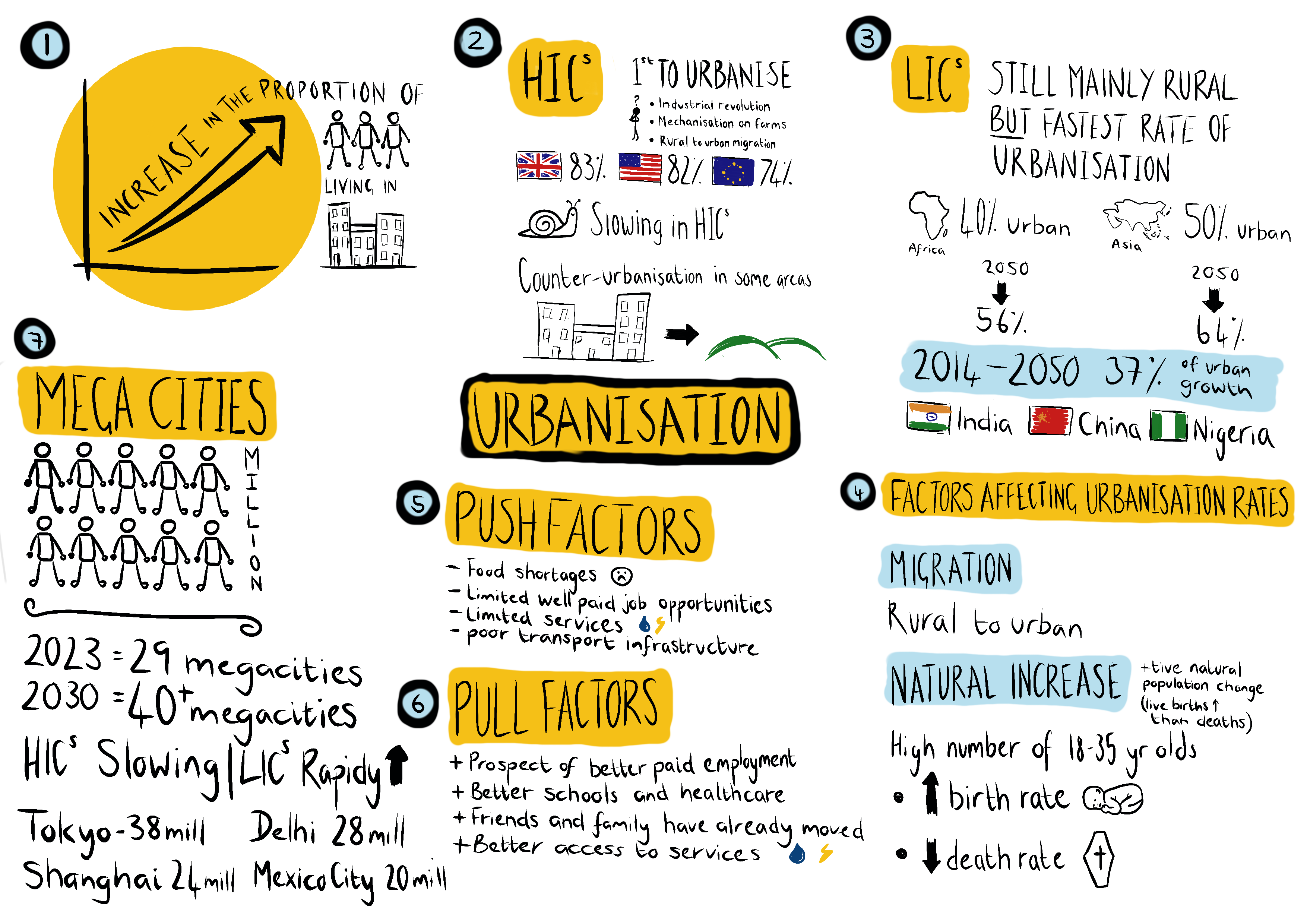
Below is my first attempt at a sketch note covering urbanisation. I still have a few tweaks (the data for megacities needs some work to make it more ‘sticky’), so let’s call it a first draft. Please, don’t judge my dodgy drawing skills and left-handed scrawl!
The sketch note above was created using Procreate on an iPad. However, sketch notes can just as easily be created using other apps or with paper and felt tips or the holy grail of geography, pencil crayons.
The sketch note below was also created using Procreate on an iPad. However, it could easily be produced using paper and pens.
I’ve found several advantages and disadvantages to using sketch notes. Let’s focus on the positives first. The first benefit I found was that I could recall the information on the sketch note. Several days after creating the sketch note, I could recall all the key statistics, and for someone with the short-term memory of a sieve, I was pretty blown away by this. Secondly, creating the sketch note made me carefully consider the information I would include and plan the sketch note. This process made me evaluate the information I had at hand (for the experiment, I used a GCSE Geography revision book) and carefully consider the most important information I should include. At the moment, I’m thinking batch-making sketch notes and giving them to students will remove some of their power. Lastly, I was proud of my first attempt and felt engaged and motivated to explore this technique further (and write this blog post about it!). I’ve come across lots of educational snake oil in my time, and this is not an example. I’ve concluded that this is a powerful tool for improving recall. I’d be interested in exploring its wider application (any geography departments interested in exploring this, do let me know!).
On to the disadvantages. The sketch note took me quite some time to create. I redrafted several areas and didn’t quite get the layout right the first time. Perhaps this is part of the learning experience, and I will get it right next time now I have a bit of experience. Also, my drawing skills are not the best so I had to get some inspiration from the Internet. I’ve started creating a cheat sheet with images and icons I can use next time to overcome this. The perfectionists out there might find this challenging. Because I created this on an iPad, I spent too much time redrafting sections of the sketch note. Perhaps committing it to paper might make me less fussy about it looking ‘perfect’.
Using sketch notes for revision in geography could be an effective way to help students retain key information. With the vast amount of data and concepts to remember in geography, it can be difficult to keep everything straight in one’s head. Sketchnotes can help to organise this information into a visual format, making it easier to understand and remember.
For example, when studying urbanisation, there are many key facts and figures to remember, such as the percentage of the world’s population that lives in urban areas and the rate of urbanisation in different regions. Using sketch notes, students can create diagrams, charts, and maps to represent this data visually. They can also use symbols and images to represent key concepts, such as the impact of urbanization on the environment and society.
In addition to helping with memory, sketch notes can be a fun and engaging way to revise geography. Students can use different colours and styles to create visually appealing notes that they are more likely to enjoy reviewing. This can help to make revision less stressful and more enjoyable.
To start with sketch notes, students can create a basic layout for their notes. This might include a central theme or topic, with different branches representing key concepts or subtopics. They can then use images and symbols to represent these ideas, with arrows and lines connecting them to show the relationships between concepts.
When revising geography, it is important to focus on understanding key concepts and their relationships rather than just memorising facts and figures. Sketchnotes can help students to do this by breaking down complex ideas into simpler components and representing them visually. This can help to create a deeper understanding of the subject matter, which is essential for success in geography.
I would be tempted not to launch using sketch notes with students close to final exams. They will likely struggle to get through the content. Instead, I’d be tempted to teach them how to use sketch notes early on in the course and then set it as regular homework or, if you have time, have review lessons where the students can summarise learning using the technique.
I’d be interested in hearing your thoughts on using sketch notes. If it is something you’d like to try, please drop me an email. If there’s enough interest, I’d happily put together some guides and cheat sheets to support your students using the technique.
Seasonal food refers to the times of the year when the harvest or the flavour of a given type of food is at its peak. This is usually the time when the item is harvested. Before supermarkets, most food eaten in the UK was sourced in the UK and seasonal. Fruit and vegetables were available according to the season. For example, during the summer months, lettuce and strawberries were widely available, whereas, during the winter, parsnips and cabbage were sold. Food was also preserved by being bottled, frozen and pickled.
Today, we are used to enjoying seasonal fruit and vegetables throughout the year. However, because some food cannot be grown throughout the year in the UK, it has to be imported from other countries, along with food that is not native to the UK, such as avocado and mango. Therefore, there has been an increase in food being imported into the UK.
According to the British Retail Consortium (BRC), a trade group, UK supermarkets import 95% of their tomatoes and 90% of their lettuce in December and typically import the same proportions in March.
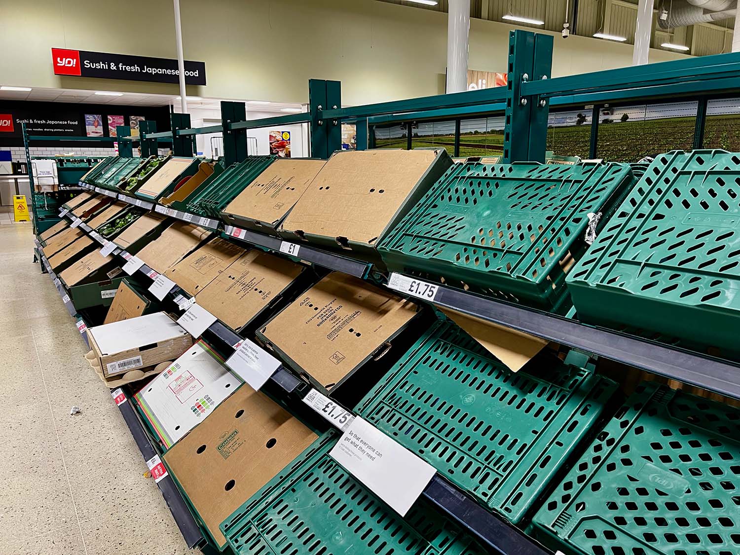
Why is fresh food in the news?
Three big supermarkets in the UK have restricted how much fresh food people can buy, such as tomatoes, cucumbers, and peppers. This is because they want to ensure enough food for everyone and don’t want the shelves to be empty. We don’t know yet if other shops will also have restrictions or if there will be a shortage of other types of food.
Fresh food shortages in UK supermarkets – Empty shelves in Tesco.
How big is the problem?
Morrisons and Asda supermarkets in the UK have restricted how much fresh food people can buy. Morrisons says people can only buy two packs of tomatoes, cucumbers, lettuce and peppers, and Asda says people can only buy three packs of broccoli, cauliflower, raspberries, and lettuce. On Wednesday, Tesco and Aldi said people could only buy three packs of peppers, cucumbers, and tomatoes. Other supermarkets haven’t said anything yet, but some people think there might not be enough food for a few weeks.
What is behind the shortages?
Getting fresh fruits and veggies in the UK is becoming harder because of two problems. First, the weather in Europe and North Africa has been bad, so there isn’t as much food to import. Second, it costs more for UK and Dutch farmers to grow their crops in greenhouses because of higher energy bills, and they planted less food this winter. This means there’s not as much food in the UK, and stores have to rely more on getting food from Spain and north Africa, which were also hit by bad weather. This has led to a shortage of some types of fresh food.
Are things worse in the UK than the rest of Europe?
It seems like France and Germany aren’t having the same problems as the UK when it comes to getting enough food. There’s not as much fresh food in the UK because the weather hasn’t been good, and British farmers aren’t producing as much as usual. This means there’s not enough food, and stores have to ration how much people can buy. The National Farmers’ Union president says there might be even more rationing if the farmers have to pay high energy bills. Some farmers also waited to plant their crops because they weren’t sure it was a good idea with all the problems. It will take a few weeks before the UK can make enough food to fill in the gap. This means stores have to buy food from Spain and Morocco, but there’s not enough to go around, so stores might not have as much food as they need and might have to pay more for it.
So is Brexit to blame?
Many farmers and suppliers don’t think that the UK leaving the EU is the only reason why there’s not enough food in stores. However, some farmers say that Brexit and the pandemic have made things harder because they have to pay their workers more because there aren’t enough. Some people who bring food into the UK from other countries say that Brexit has made it harder to get it here on time because of more paperwork and higher costs. This is especially difficult for food that goes bad quickly and must be moved quickly.
What other food stuffs might run short?
Salad foods like cucumbers, tomatoes, and lettuce are hard to find now. It’s also tough to get aubergines, lemons, broccoli, and lettuce from Spain. In the UK, frost damaged crops like cabbage and cauliflower. But that’s not all. There’s also a shortage of eggs because of a bad bird flu outbreak. All the birds must be kept inside, making it expensive to keep them warm and lit. So, there aren’t as many eggs being made in the UK as usual. One big supermarket, Sainsbury’s, has had to get eggs from Italy because there aren’t enough in the UK.
What could be done to help the situation?
The National Farmers Union wants the government to help British farmers who rely on energy. The president, Minette Batters, thinks it’s unfair that botanical gardens with large glasshouses get help with their energy bills, but food producers with greenhouses don’t. The farming minister, Mark Spencer, says the government is looking into this.
Even though salad crop prices are increasing, farmers might not make more money because they have contracts with supermarkets and suppliers that set prices. Some farmers are upset because supermarkets sell food too cheaply, below its cost. But supermarkets don’t want to raise prices too much and lose customers during the cost of living crisis.
https://www.internetgeography.net/wp-content/uploads/2023/02/Fresh-food-shortages-in-UK-supermarkets.jpg11251500Anthony Bennetthttps://www.internetgeography.net/wp-content/uploads/2024/01/Internet-Geography-Logo.pngAnthony Bennett2023-02-26 12:00:052023-02-26 12:00:05Food shortages in the UK
We’re collating resources to support teachers covering the recent devastating earthquake in Turkey. First and foremost, we’ve shared links to anyone who can support NGOs working to help those affected. Additionally, there are links to support teachers in sensitively delivering events such as the earthquake, including advice on supporting the young people affected.
Earthquake Relief
There are many aid agencies providing support to those affected by the recent earthquake that has affected tens of thousands of people in Turkey and Syria, including:
Please email us if you are aware of other aid agencies providing support or can provide a link for donations to aid agencies.
Support
Teachers
Below we have included links to websites that support teaching events such as this in a considered way. After all, many children from Turkey and Siria are being educated in schools outside of the country and may be in one of your classes.
Newly available Maxar satellite imagery shows several hundred meters long surface rupture with horizontal displacements up to 4m near Nurdağı, Gaziantep province, Turkey. pic.twitter.com/3JVZTTHrk1
The M7.8 earthquake in Türkiye occurred on a strike-slip fault. During this type of faulting event one side of the fault slides horizontally past the other. Things that cross the fault like fences, roads or train tracks are good markers for showing the way the fault moved. https://t.co/uAxHsDnf59pic.twitter.com/XreVABZnl1