River Fieldwork Techniques
Rivers are popular locations for completing geographical investigations.
Rivers are popular locations for completing geographical investigations. This is because they are dynamic systems, which means they are constantly changing. Processes of erosion, transportation and deposition lead to changes along the long profile of a river as well as its cross profile.
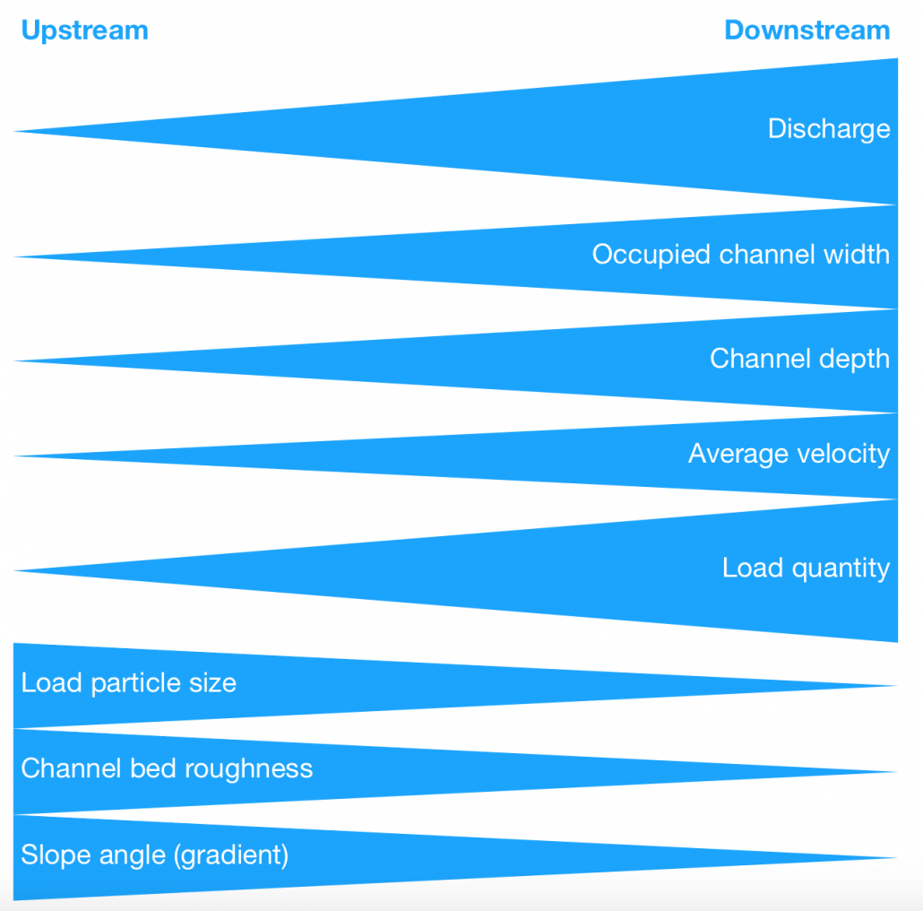
When investigating rivers the Bradshaw Model can be used to create questions and hypothesis to investigate.
The Bradshaw Model
The Bradshaw Model suggests that certain changes occur along the long profile of a typical river. For example, discharge increases as you move downstream of a river or bedload (material on the river bed) particle size decreases along the river channel.
Questions that can be investigated during river fieldwork include:
Questions that focus on changes along the long profile or downstream changes support in developing a hypothesis. A hypothesis is a statement, usually an educated guess, that you will either prove or disprove through the data you collect as part of your investigation.
In order to prove or disprove your hypothesis, you will need to collect primary data as part of your investigation. Depending on what your hypothesis is you will need to decide what data you need to collect and how you will do this. This forms part of your investigation method.
What is the discharge of a river?
The discharge of a river is the volume of water flowing through a river channel. It is usually measured in cubic metres per second.
How do you measure it?
It is not possible to measure river discharge directly in the field. Instead, you need to take measurements that allow you to calculate discharge.
Discharge(m3/s) = Cross sectional area(m2) × Velocity (m/s)
Cross sectional area (m2) = Width(m) × Mean depth(m)
In order to calculate Discharge we must measure Width, Depth and Velocity.
Why measure it?
According to the Bradshaw model as you move downstream river discharge should increase. This is because tributaries will feed the river leading to an increase in discharge.
What is the velocity of a river?
The velocity of a river is the speed the water flows. The velocity will change along the course of a river.
How do you measure it?
If you have a flow meter it is very easy to measure the velocity of a river in the field. If you don’t have a flow meter you can take measurements in the field using a float, stopwatch and tape measure. Once you have recorded the appropriate data you can use the formula below to calculate the velocity.
Velocity = Distance / Time
There is a range of things you can use for a float including an orange. We recommend dog biscuits because they break down in water if swept away!
To gather your data you need to measure a distance of 5 metres downstream. Place your float in the water upstream at 0m. Record the time it takes for the float to travel 5m. Repeat this three times and calculate the mean. Next, use the above formula to calculate the velocity.
Why measure it?
According to the Bradshaw Model velocity increases from source to mouth.
What is river depth?
River depth is how deep a river is. Depth changes across a river channel due to material on the river bed. Therefore, it is useful to calculate the mean depth.
How do you measure it?
Place a metre ruler into the river until it touches the river bed. Record the distance between the river bed and the surface of the water. You should do this at regular intervals between the banks of the river. Add the depths together and divide by the number of recordings you took to calculate the mean depth.
Tip: If the bed is rough and bumpy, you will need more measurements at closer intervals to get an accurate result.
Why measure it?
To calculate the cross-sectional area you will need to know the mean depth. According to the Bradshaw Model depth increases from the source to the mouth of a river.
What is the width of a river?
The width of a river is the distance between the points where water comes into contact with each river bank.
How do you measure it?
Extend a tape measure from the point where the dry bank meets the water on one side of the river to the same point on the other side (hold it taut about 20cm above water level). Record the length, viewing the reading from directly above the tape measure.
Why measure it?
Measuring the width of the river channel enables you to calculate the cross-sectional area. Also, according to the Bradshaw Model, channel width increases downstream.
What is the wetted perimeter?
The wetted perimeter or occupied channel width is the entire length of the bed and river bank (sides) in contact with water.
How do you measure it?
Wetter perimeter = Width + Depth + Depth
Why measure it?
According to the Bradshaw Model, the wetted perimeter of a river should increase along its course.
What is the cross profile?
River cross profiles show you a cross-section of a river’s channel and valley at certain points in the river’s course.
How do you measure it?
Multiply the average depth by the width of the river channel.
Why measure it?
The cross profile of a river changes as it moves from the upper to lower course as a result of changes in the river’s energy and the processes that the river carries out.
What is sediment size and type?
The aim of this is to measure the size and shape of a sample of stones from each site visited in the river.
How do you measure it?
At each site along the river move across the river and select 10 different stones found on the river bed. You should use a random method of collection – put the metre ruler into the water and pick up whatever stone it is touching. Use the ruler or callipers to measure the long axes of each stone (the longest two points on the stone) – this should be recorded in cm.
Use the Powers Index of Roundness to observe and compare the shape of the stone and record this.
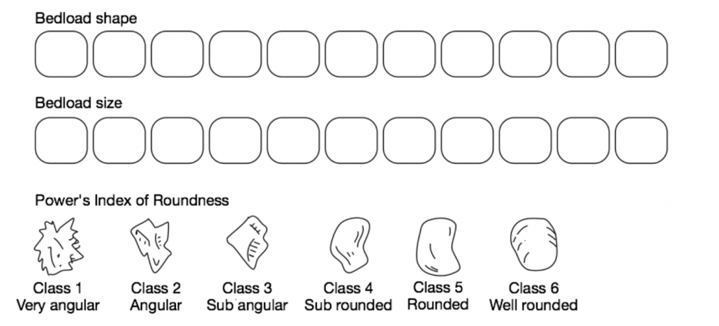
Power’s Index of Roundness
Why measure it?
Load particle size decreases along the long profile of a river. Bedload becomes less angular along the course of a river.


