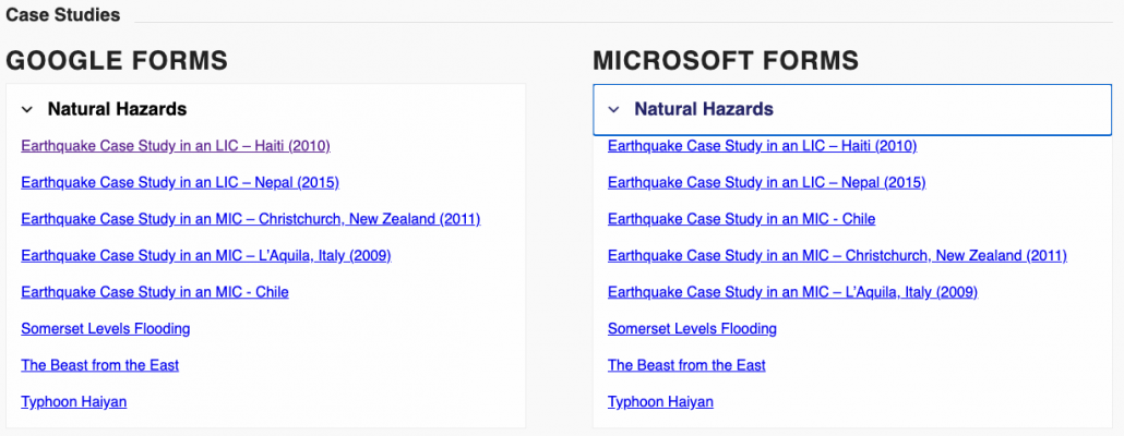
With the increasing use of Google and Microsoft forms for remote learning, we’ve converted many of our multiple-choice booklets into Google and Microsoft forms for Internet Geography Plus subscribers to copy. Forms are self-marking which saves you time!
So far, Plus subscribers have access to all the AQA GCSE paper 1 and 2 quizzes, Edexcel A and B quizzes are being developed (there are several units for both specs) along with OCR.
We are also developing a bank of case study multiple choice quizzes too.
Case Study Multiple Choice Quizzes
As well as developing a bank of multiple-choice quizzes in Microsoft and Google Forms format, we are also developing a collection of self-marking, short answer quizzes too. Over the coming weeks, there will be a large number of these quizzes added to the Plus area of Internet Geography. To illustrate what these quizzes will look like, and hopefully save you some time, we’re sharing one of these quizzes in Google and Microsoft Form format. Just click the links below to copy the quizzes (please ensure you are logged into your Google/Microsoft account before clicking the links).
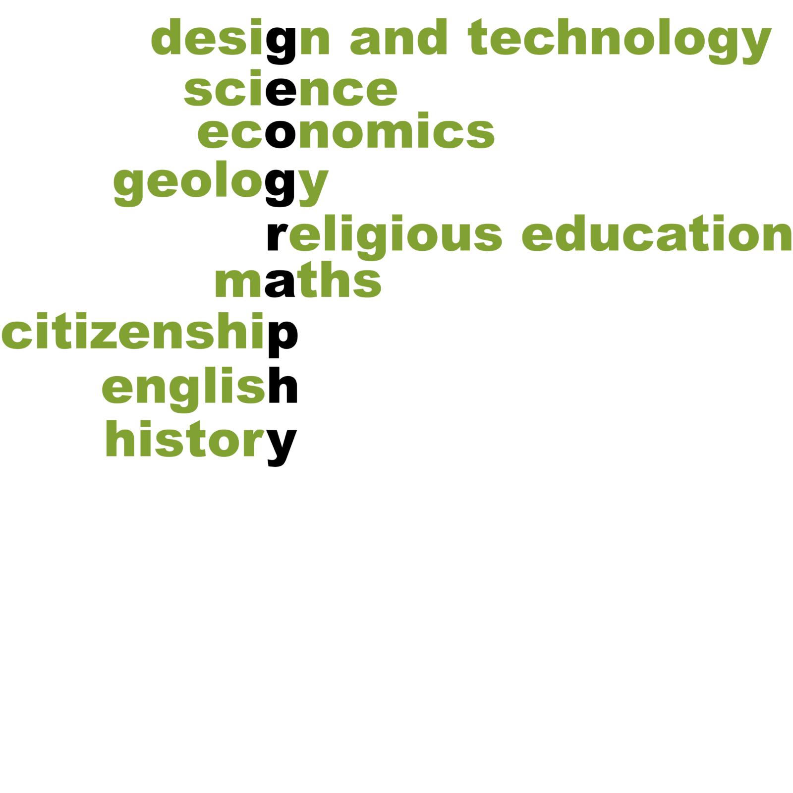
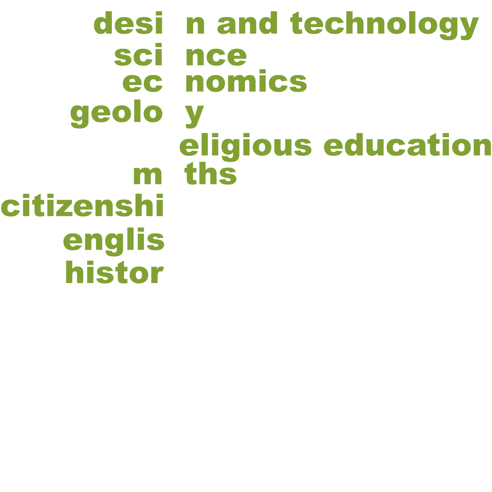
We are developing a new, open access revision area on Internet Geography, to support students with retrieval practice. The resources will consist of a bank of online gap-fill activities that students can use to revisit prior learning.
The activities will be freely available with no requirement to register, pay to access or log in.
Each gap-fill will come in two forms, an open gap fill where students need to recall keywords and factual information along with a drag and drop version. The two versions are illustrated below.
We’re seeking support from the geography teacher community to develop these revision activities by contributing a paragraph or two of text to summarise key elements of each GCSE geography unit across all exam boards.
When contributing just head over to the submission form and add your paragraph. When contributing your paragraph missing words should be enclosed within an asterisk. e.g. *Constructive* waves build beaches. These waves are more common in *summer* than in winter. Constructive waves predominate in calmer weather conditions when less energy is being transferred to the water. Each wave is low. As the wave *breaks* it carries material up the beach in its *swash*. The beach material will then be deposited as the backwash soaks into the sand or slowly drains away. When the next wave breaks its swash will deposit more material without it being ‘captured’ by the backwash of the preceding wave.
Alternative answers should be separated using a forward slash e.g. *conservative/passive* plate margins….
You can also add a tooltip (pop up hint) to support students with the answer by including a colon e.g. *conservative/passive:Where to plates slide past each other* plate boundaries.
To begin with will focus on one unit at a time for each exam specification. To avoid repetition please identify the paragraph you will complete on this Google Sheet. When you’ve submitted it using this form please indicate it has been completed on the Google Sheet.
If you’ve any questions, please contact by adding a comment below.
https://www.internetgeography.net/wp-content/uploads/2020/10/zfonrql2xbbshfuouqrxsoyotikddmdnd6wrpvgfbcpxosda.png11371080Anthony Bennetthttps://www.internetgeography.net/wp-content/uploads/2024/01/Internet-Geography-Logo.pngAnthony Bennett2020-10-03 19:05:512020-10-04 10:06:50One subject to unite all
If you’ve not seen Extinction: The Facts yet, you must grab an hour to watch it. It’s available on iPlayer for a year. The legend that is David Attenborough, along with many experts, explore the issues relating to the decline in global biodiversity. With more synoptic links than you could shake a stick at the programme is divided into a series of sections:
An introduction to biodiversity (00.00 – 08.35 mins)
Consequences of losing biodiversity (08.35 – 13.20 mins)
How are we destroying the ecosystems we depend on? (13.20 – 41.32 mins)
How did it come to this? (41.30 – 44.55)
What can we do to slow the decline in biodiversity? (44.55 – 51.42 mins)
Nature can bounce back – Poppy and the mountain gorillas (51.42 – 56.69 mins)
We’ve produced a worksheet containing questions that students can complete while watching the programme. It’s fully editable so you can adapt the resource for your students (we went a bit mad with the number of questions!). There is also a set of answers accompanying the resource.
We’ve brought you these free resources through the support of those who have subscribed to Internet Geography Plus. If you’ve not got one please consider taking out a low-cost subscription now or you could buy us a coffee.
If you download this resource and adapt it please send us a copy via [email protected]
Please don’t share this resource on other sites etc.
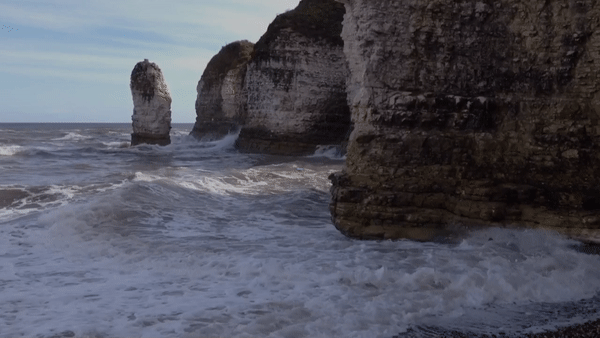
Can’t take your students to Flamborough? Take Flamborough to your students!
Check out this virtual 360° tour of Selwicks Bay, Flamborough. The images were captured using a GoPro Max 360° camera.
We’re fund raising to develop more 360° tours like this. Our next project will be a 360° interactive tour of the River Tees. Please take a look at our Just Giving page.
Click the square in the navigation circle to go full screen.
https://www.internetgeography.net/wp-content/uploads/2020/08/Flamborough-Tour-scaled.jpeg5331600Anthony Bennetthttps://www.internetgeography.net/wp-content/uploads/2024/01/Internet-Geography-Logo.pngAnthony Bennett2020-08-30 20:31:542020-10-26 19:43:43Selwicks Bay Flamborough 360 Tour
Through the support of Internet Geography Plus subscribers, we can bring you up to date case study information such as this. Please consider supporting us with an Internet Geography Plus subscription.
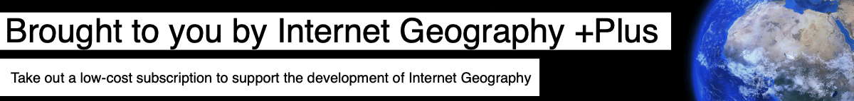
Withernsea is a town located on the Holderness Coast in the East Riding of Yorkshire.
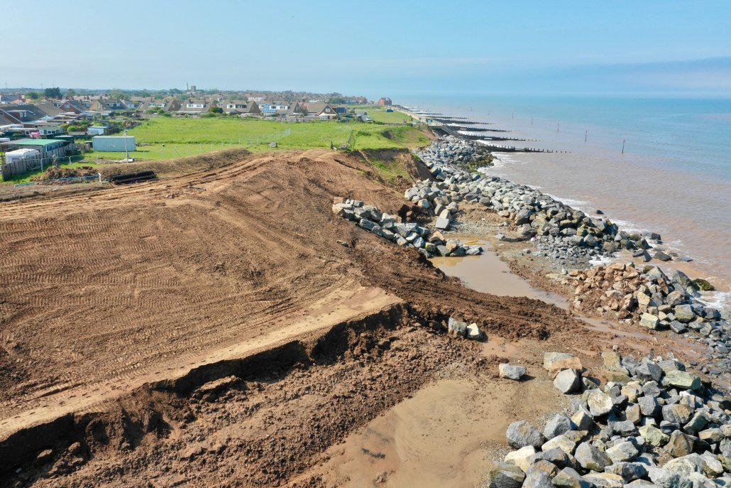
The front of Withernsea has extensive coastal defences including a sea wall, groynes and rock armour. To the south of Withernsea, the sea defences have been extended several times using rock armour. Beyond the sea defences, rates of erosion have increased because beach material is not being replaced as groynes trap sediment being transported by longshore drift along the front of Withernsea. As the beach in this area is very gently the North Sea reaches the base of the cliffs even during neap tides, leading to increased cliff erosion. This stretch of land is some of the most rapidly eroding along the Holderness Coast.
Withernsea – Terminal Groyne Effect (image was taken prior to the extension of rock armour in 2020)
The increased rate of erosion has led to the rapid loss of land, particularly along the front of the Golden Sands Holiday Park. More than 20-holiday homes have had to be either demolished or moved in the last few years. Also under threat is the main road connecting the village of Holmpton to the town of Withernsea.
Erosion on this section of the Withernsea coastline has historically been at an average of around 4m per year, but in recent years this has increased to approximately 6m per year in places, with 2019 seeing around 12m of erosion opposite the frontage of the Golden Sands Holiday Park.
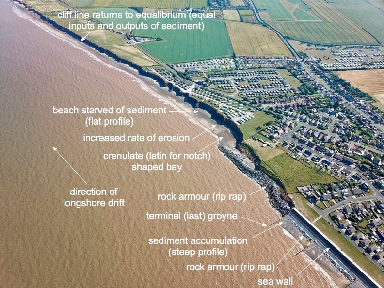
Erosion at Golden Sands Holiday Park between 2018 and 2020
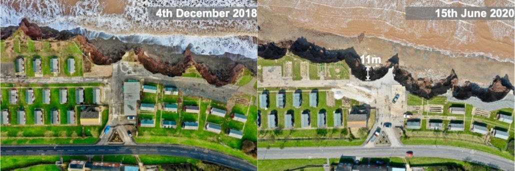
To protect Holmpton Road, local houses and businesses being lost to coastal erosion, new sea defences have been installed. Four hundred metres of rock armour has been installed along this stretch of coast. During 2020 just under 70,000 tonnes of anorthosite, a rock similar to granite, was transported from Norway to the site off Golden Sands Holiday Park. The project will protect about 70 homes and more than 250-holiday chalets and static caravans.
A £3m grant, which allowed the £7 million scheme to go ahead after other bids had failed, was provided by the European Regional Development Fund at the end of 2019.
The rock was transported from the quayside quarry in Rekefjord, on the southern coast of Norway, in 5000-tonne shipments by barge. The rocks were then dropped from the barge using heavy machinery when weather conditions were favourable. When the tide went out the rock was then transported up the beach.
Rock being dropped from a barge
The majority of the rocks weigh between six and ten tonnes, but some reached as much as fifteen tonnes. The boulders were used to create an interlocking rock structure, designed to prevent the sea from eroding the cliffs. This is thought to be amongst the largest used in such defences around the UK.
Rocks of this size were required to withstand the rough seas that this stretch of coastline can experience, both now and in future, should climate change produce the expected worsening of sea conditions. Rock armour is an interlocking but porous structure that has proven to be effective at withstanding wave action, which is the primary cause of the areas rapid coastal erosion.
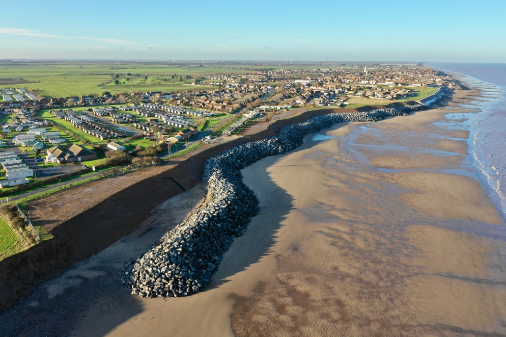
The cliffs to the south of Withernsea have been re-profiled, and rock armour has been placed onto the newly gently sloping cliffs and along their base.
Cliff reprofiling and the first installation of rock armour
Construction started in May 2020 and was completed on 17th December 2020.
Completed coastal defences at Withernsea on 17th December 2020.
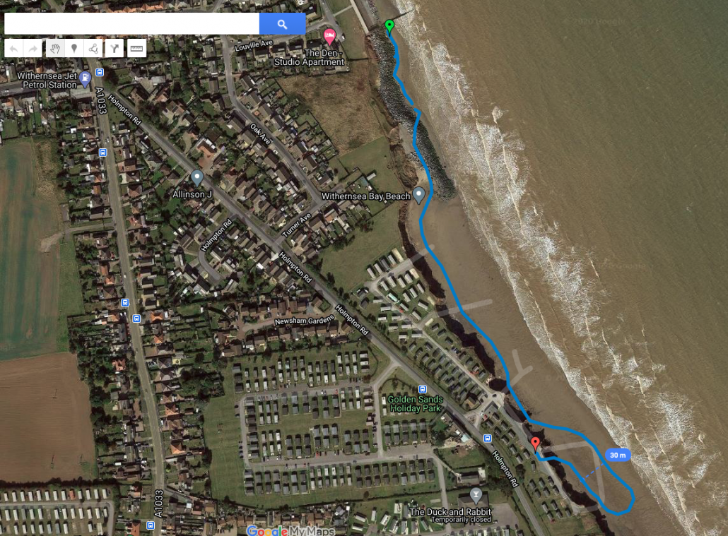
It may take some time for aerial images on Google Maps to update to include the new rock armour at Withernsea, However, the image below shows the beachside outline of the new defences. In some places, the rock armour is 30m wide!
GPS outline of the new defences at Withernsea
Rates of erosion are expected to increase to the south of the new defences.
Photo gallery
This gallery will be updated over the coming months. Feel free to use these images in your classroom. Please remember to credit www.internetgeography.net. If you would like to use these images in the public domain or for commercial purposes, please contact us.
Following on from the popular geography reward cards/postcards, We’ve created a series of GIFs that can be sent to students electronically or used on social media. You can download these below.
Just started having a play with developing some reward postcards/cards that can be used to send to students during the lockdown period. I’ll be adding more over the coming days.
These resources were designed for Rachel’s year 9s to use at home for distance learning, completing a decision-making exercise. It is based on the topic of Africa, and Development that Rachel’s pupils have studied in school this year. However, it also offers synoptic elements and asks pupils to work on their skills.
The idea came from the AQA paper 3 this summer that was not sat – however this has been put together independently of that (beyond the same theme), all sources should be referenced, with links to original sources. Data was accurate at the point of construction (May 2020)
It is divided into three sections – Section A is based on reading and interpreting a range of graphs and maps with reference to urbanisation.
Section B builds a bit more onto the issues associated with shanty town development in cities across Africa. Resources this time are wider including newspaper articles and a travel journal.
Finally, the final section asks pupils to make a decision. Ideally utilising work from previous sections.
Each section of information has a booklet of tasks to go along with it.
This could be adapted and set to any year group – we will also use it with our new year 12 cohort as they missed Paper 3 (AQA) this year.
There are quizzes that accompany it on quizizz – search shanty towns of Africa recap.