A landscape is the result of natural and human processes interacting over time. The UK’s landscape has been shaped by the types of rock found beneath the surface, past tectonic events, and glaciation.
The UK’s Main Rock Types
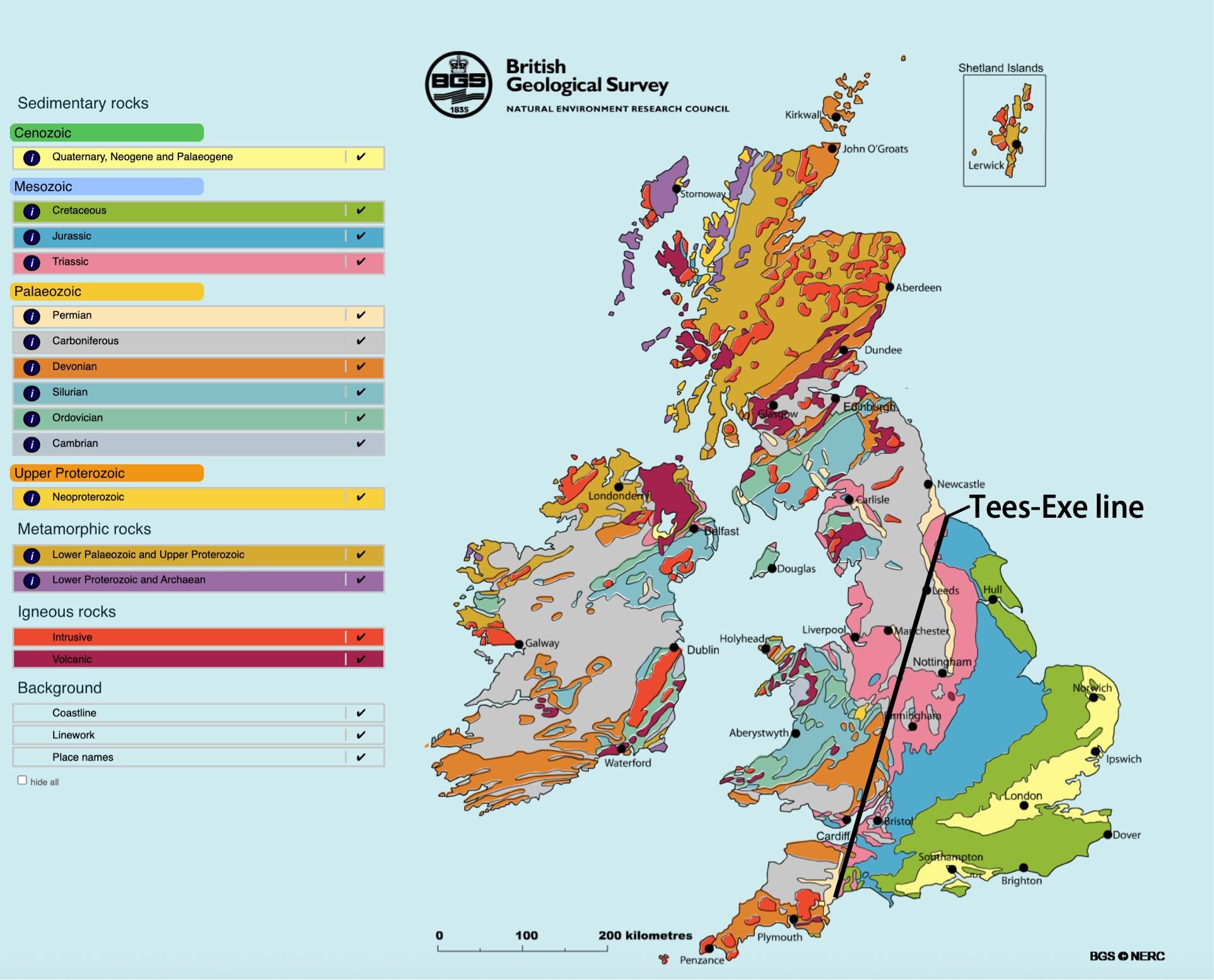
There are three main groups of rock found across the UK. These are igneous, sedimentary, and metamorphic. The map below shows the distribution of the different types of rock.
Properties: Vary in hardness. Chalk and limestone are permeable; clay is impermeable.
Locations: Common in lowland areas of southern and eastern England.
Landscape features: Chalk forms dry valleys and gentle hills; clay forms flat, waterlogged plains.
Metamorphic Rocks
Formed: When existing rocks are altered by heat and pressure.
Examples: Slate, schist.
Properties: Very resistant, impermeable.
Locations: Upland areas such as Snowdonia and the Grampians.
Landscape features: Often rugged and steep.
Past Tectonic Activity
The movement of tectonic plates shaped the UK’s geological history:
The UK was once near a plate boundary and experienced volcanic activity, creating granite landscapes.
The collision of plates caused the folding and uplifting of rock layers, forming mountains like the Scottish Highlands and the Lake District.
Pressure and heat during these events transformed rocks into metamorphic types like slate and schist.
Much of the UK was once submerged beneath warm shallow seas, leading to the formation of chalk and limestone.
The Tees–Exe Line
This imaginary line runs from the River Tees (northeast) to the River Exe (southwest). It roughly divides:
Upland areas to the north and west – harder rocks, more resistant to erosion.
Lowland areas to the south and east – softer rocks, more easily eroded.
Glaciation and the UK Landscape
Glacial processes during the Ice Age shaped both upland and lowland areas:
Upland erosion: Glaciers carved U-shaped valleys, corries and arêtes, especially in places like Snowdonia and the Lake District.
Lowland deposition: Meltwater and ice left behind boulder clay, especially in East Anglia.
The southernmost extent of ice coverage is marked roughly by the Tees–Exe Line.
Permeability and Drainage
Permeable rocks like chalk allow water to drain through, creating dry valleys and thin soils.
Impermeable rocks like clay and granite lead to waterlogged soils and poor drainage.
Drainage affects land use: for example, clay areas are often used for pasture due to wet conditions.
Rock Type
Resistance
Permeability
Landscape Type
Location
Igneous
High
Impermeable
Upland, boggy
Dartmoor
Sedimentary
Variable
Chalk: permeable Clay: impermeable
Lowland, varied
Southern UK
Metamorphic
Very high
Impermeable
Steep uplands
Snowdonia
Summary
UK Rock Types
The UK is made up of three main rock types: igneous, sedimentary, and metamorphic, each with different origins, properties, and impacts on landscape features.
Tectonic History
Past tectonic activity uplifted, folded, and faulted rocks, forming mountain ranges (e.g. Highlands, Lake District) and transforming some rocks into metamorphic forms like slate and schist.
The Tees–Exe Line
An imaginary line from the River Tees to the River Exe divides upland areas (north/west, hard rocks) from lowland areas (south/east, softer rocks).
Impact of Glaciation
Glaciers eroded uplands into U-shaped valleys and corries, while lowlands were shaped by deposition, leaving boulder clay especially in areas like East Anglia.
Permeability and Drainage
Permeable rocks like chalk allow water to drain, forming dry valleys; impermeable rocks like clay and granite lead to waterlogged soils and poor drainage.
Landscape Formation
Rock resistance and permeability influence landscape types: igneous and metamorphic rocks form rugged uplands, while sedimentary rocks shape rolling lowlands and clay plains.