Location of Lagos
Lagos, Nigeria, a case study of a city in a low income country (LIC).
Nigeria is Africa’s most populated country. Lagos is its largest city, located in the southwest on the coast of the Gulf of Guinea, close to its border with Benin. Although the city is no longer the country’s capital, having been replaced by Abuja in 1991, it is Nigeria’s most important city for economic reasons.
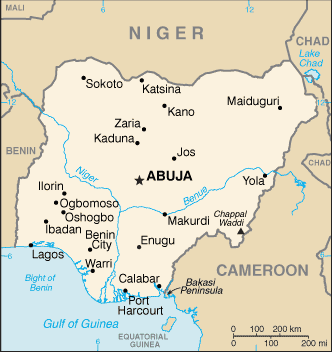
A map to show the location of Lagos in Nigeria
The city was originally a tiny fishing village on an island until Portuguese settlers arrived in the 15th century. In the early twentieth century, it became the capital city of Nigeria until 1991, when the government moved to Abuja.
Lagos’s population increases by approximately 600,000 each year. The Lagos State Government estimates it at 17.5 million. However, the Nigerian government has disputed this number and found it unreliable by the National Population Commission of Nigeria, which put it at over 21 million in 2016. Regardless of which is most accurate, Lagos has the highest population of any African city.
As the population of Laos has grown, so has the city’s physical size. The original settlement consisted of Lagos Island. By the 1960s, the city had expanded north into the mainland. Urban growth occurred along the railway line. A population boom occurred during the 1970s due to the growth of the oil industry. Many thousands of people moved to the city seeking jobs in this industry. Urban growth continued during the 1980s and 1990s. Find out more about the growth of Lagos.
From above, the city looks like any modern city. The city centre skyline is dominated by modern, high-rise offices, surrounded by miles of sprawling suburbs linked by busy roads.
At street level, the air is filled with noise from generators that power the city due to unreliable energy supply, motorbikes, and yellow minibus taxis.


Use the images below to explore related GeoTopics.