The earthquake occurred on January 12th, 2010, at 16.53 local time (21.53 GMT).
Where?
The earthquake occurred at 18.457°N, 72.533°W. The epicentre was near the town of Léogâne, Ouest department, approximately 25 kilometres (16 mi) west of Port-au-Prince, Haiti’s capital. The earthquake’s focus was 13km (8.1 miles) below the Earth’s surface.
Why?
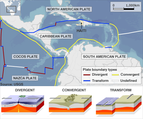
Haiti is situated at the northern end of the Caribbean Plate, on a transform (slip/conservative) plate boundary with the North American Plate. The North American plate is moving west. This movement is not smooth, and there is friction between the North American Plate and the Caribbean Plate. Pressure builds between the two plates until released as an earthquake.
A map to show the location of Haiti in relation to tectonic plates. Source BBC.
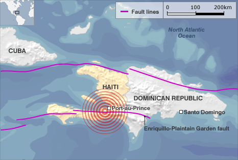
The epicentre of the earthquake was 16km southwest of Port-Au-Prince. The earthquake was caused by a slip along an existing fault (Enriquillo-Plaintain Garden fault).
A map to show the location of the epicentre of the earthquake
Primary Effects
As of February 12th 2010, an estimated three million people were affected by the quake; the Haitian Government reports that between 217,000 and 230,000 people died, an estimated 300,000 were injured, and an estimated 1,000,000 were made homeless. They also estimated that 250,000 residences and 30,000 commercial buildings had collapsed or were severely damaged.
Secondary Effects
Two million people were left without water and food.
Regular power cuts occurred.
Crime increased – looting became a problem and sexual violence escalated.
People moved into temporary shelters.
By November 2010 there were outbreaks of cholera.
Immediate Responses
Due to the port being damaged, aid was slow to arrive.
The USA sent rescue teams and 10,000 troops.
Bottled water and purification tablets were provided.
235,000 people were moved away from Port-au-Prince to less-damaged cities.
£20 million was donated by The UK government.
Long-term Responses
As one of the poorest countries on Earth, Haiti relied on overseas aid.
Although the response was slow, new homes were built to a higher standard. Over one million people still lived in temporary shelters one year after the earthquake.
The port needed rebuilding, which required a large amount of investment.
So, why did so many people die in the Haiti earthquake? There are several reasons for this:
The earthquake occurred at shallow depth – this means that the seismic waves must travel a smaller distance through the Earth to reach the surface to maintain more energy.
The earthquake struck the most densely populated area of the country.
Haiti is the poorest country in the Western Hemisphere
The buildings in Port-Au-Prince and other areas of Haiti were generally in poor condition and were not designed or constructed to be earthquake-resistant.
Three million people live in Port au Prince; most live in slum conditions after rapid urbanisation.
Haiti only has one airport with one runway. The control tower was severely damaged in the earthquake. The port is also unusable due to damage.
Initially, aid had been piling up at the airport due to a lack of trucks and people to distribute it. Water and food have taken days to arrive, and there is not enough to go around.
Rescue teams from around the world took up to 48 hours to arrive in Haiti due to the problems at the airport. As a result, local people have had to use their bare hands to try and dig people out of the rubble.
There has been a severe shortage of doctors, and many people have died of injuries like broken limbs.
Web Links
The BBC News website has a comprehensive overview of the earthquake here. In addition, the BBC has produced an excellent article titled Why so many people died in the Haiti earthquake? and provides comparative data with similar earthquakes.
Related Topics
Use the images below to explore related GeoTopics.


