Different rocks create contrasting landforms and landscapes
The geology of an area is one of the key factors influencing the shape of the landscape:
Granite Landscapes
Granite is a resistant, impermeable rock. Dartmoor National Park is located on top of an exposed batholith. On Dartmoor, there are many rock outcrops (over 150) known as tors (see image below).
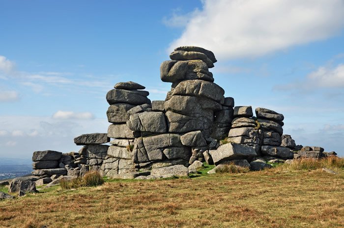
Great Staple Tor on Dartmoor – Source
These tors have been formed by a combination of freeze-thaw weathering and hydrolysis (a form of chemical weathering). Granite often has joints that are not evenly spread. Freeze-thaw and chemical weathering wear down the rock areas with a large number of joints faster than those that don’t have cracks for water to enter. Granite areas with fewer joints tend to stick out at the surface, forming tors.
Due to the resistant nature of granite and its impermeable (it does not let water through) surface runoff is high, leading to a high drainage density. Flat-topped moorland typifies the area. Bogs are also common due to standing water, impermeable rock, and high rainfall levels.
Water flows over the surface of granite rather than through it. The numerous surface streams form V-shaped river valleys. Valley sides are steep due to the resistant nature of the granite. Granite landscapes tend to be at a higher altitude due to the resistant nature of the bedrock.
Carboniferous Limestone Landscapes (above ground)
Limestone areas provide distinct scenery known as karst. You can find out about karst here.
Carboniferous Limestone Landscapes (below ground)
Limestone environments also have distinct underground features. You can find out about them here.
Chalk Landscapes
Chalk is a sedimentary rock made up of calcium carbonate. Chalk is porous and allows water to penetrate the rock. Streams only tend to be visible when the rock is saturated. Dry valleys are a common feature in areas of chalk. These were eroded by fast-flowing surface streams towards the end of the last Ice Age.
Where the chalk (permeable) meets an impermeable rock (frequently clay), springs form and can be seen when rivers begin to flow at the surface; chalk is eroded by solution.
In the area of chalk bedrock, soils are thin, which means vegetation is mainly grasses.
Chalk forms gentle hills inland (eg the South Downs in southern England) and steep cliffs at the coast (eg the Seven Sisters in Sussex and Flamborough Head).
Chalk escarpments have a gentle slope (or dip) on one side and a steeper slope (or scarp) on the other (see image below). Chalk beds are good natural aquifers (underground areas that allow water storage due to the rock’s porous nature).
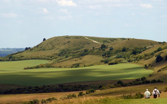
Chalk Escarpment – Source
Clay Landscapes
Clay is a sedimentary rock made of tiny particles from weathering other rocks and minerals.
The particles can be transported by rivers or ice and then deposited. Clay vales are frequently found at the foot of chalk escarpments, eg, in Southern England’s South Downs.
Clay collapses easily when wet (slumping) and forms gentle landscapes, which are frequently waterlogged. It is impermeable and is characterised by having many surface streams.
Clay is high in nutrients and is not eroded easily.


Use the images below to explore related GeoTopics.