River Landscapes – The River Tees

Edexcel B GCSE Geography > The UK’s Evolving Physical Landscape > River Landscapes – The River Tees


River Landscapes The River Tees

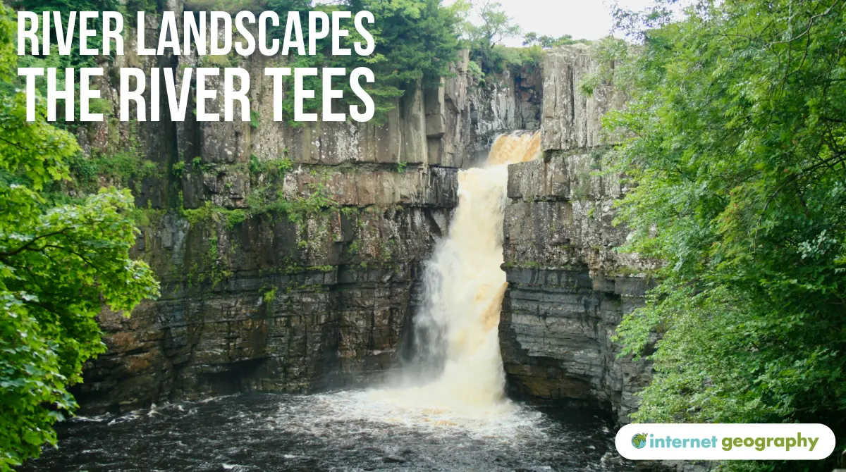
The River Tees, located in the north-east of England, is a great example of how river landscapes change from source to mouth. From the high Pennines to the North Sea, the River Tees flows over 120 km and shows clear changes in its channel shape, valley profile, gradient, discharge, velocity, and sediment.

The upper, the middle and lower course of the River Tees

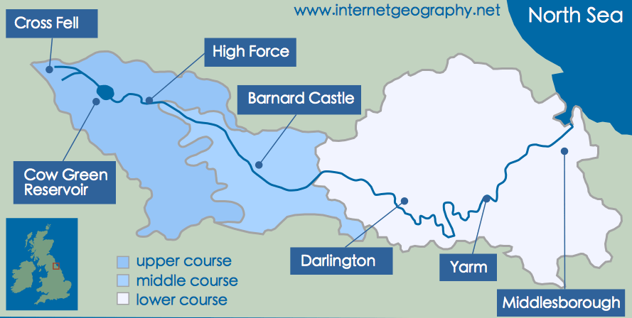
The upper, middle and lower course of the River Tees

Upper Course of a River

In the upper course of a river, typically found in mountainous or upland areas, rivers have the lowest energy due to limited discharge. Vertical erosion dominates, deepening the river valley. Erosional processes such as hydraulic action, abrasion, and attrition are most active. Transportation mainly occurs via traction and saltation due to the large size of sediment. The valley is steep and V-shaped, with interlocking spurs.

The River Tees (Upper Course)

  • Location: Source at Cross Fell, Pennines
  • Channel Shape: Narrow, shallow, rocky bed
  • Valley Profile: Classic V-shaped valley with steep sides
  • Gradient: Very steep
  • Discharge: Low, as it’s early in the river’s course
  • Velocity: Slow due to friction and rough riverbed
  • Sediment: Large, angular boulders from weathered rock
  • Key Landforms: High Force Waterfall (21m drop) formed where resistant Whin Sill lies over softer limestone; retreating waterfall creates a gorge

Middle Course of a River

In the middle course, the river gains more energy as discharge increases with added tributaries. Lateral erosion becomes dominant, widening the channel. Transportation mainly involves suspension and some saltation, and deposition begins to occur on the inside bends of meanders. The river valley becomes wider with a gentler slope.

The River Tees (Middle Course)

  • Location: Near Barnard Castle
  • Channel Shape: Wider and deeper than upper course
  • Valley Profile: Wider U-shaped valley, gentle sides
  • Gradient: Less steep than the upper course
  • Discharge: Increasing with input from tributaries
  • Velocity: Increasing due to reduced friction
  • Sediment: Smaller and more rounded, carried in suspension
  • Key Landforms: Meanders, river cliffs (outer bend erosion), slip-off slopes (inner bend deposition)

Lower Course of a River

In the lower course, the river is at its most powerful with high discharge and energy. The gradient is very gentle, and deposition becomes the dominant process. The channel is wide and deep, and the river carries fine, suspended sediment. The valley is broad with features like floodplains, levees, and oxbow lakes.

The River Tees (Lower Course)

  • Location: Near Yarm and Middlesbrough
  • Channel Shape: Very wide and deep
  • Valley Profile: Broad, flat floodplain
  • Gradient: Very gentle
  • Discharge: Highest due to full tributary collection
  • Velocity: Fastest due to smooth bed and high energy
  • Sediment: Fine, well-rounded particles in suspension
  • Key Landforms: Oxbow lakes, levees, estuary near Teesmouth

Summary of Changes

FeatureUpper CourseMiddle CourseLower Course
Channel ShapeNarrow, shallowWider, deeperVery wide, very deep
Valley ProfileSteep-sided V-shapedGentle U-shapedBroad, flat floodplain
GradientVery steepModerateGentle
DischargeLowIncreasingHighest
VelocitySlowModerateFast
Sediment SizeLarge, angularSmaller, roundedFine, well-rounded

Summary

  • The River Tees

    The River Tees flows from its source in the Pennines to the North Sea, passing through steep upland, gently sloping middle course, and flat lowland.

  • Upper Course – Steep and Narrow

    In the upper course, the River Tees has a steep gradient, narrow V-shaped valley, low velocity, and carries large angular sediment.

  • Middle Course – Meanders and Erosion

    The middle course features wider valleys and meanders like those near Yarm. Lateral erosion increases, and sediment becomes smaller and rounder.

  • Lower Course – Wide and Deep Channel

    In the lower course, near Stockton-on-Tees and Middlesbrough, the river has a wide, deep channel and large discharge. Deposition is the dominant process.

  • Changes in Sediment and Velocity

    From source to mouth, sediment size and angularity decrease while discharge and velocity increase due to tributaries and reduced friction.

  • Case Study – River Tees Landforms

    Key landforms include High Force waterfall in the upper course, meanders and oxbow lakes in the middle course, and floodplains and levees in the lower course.

Flashcards

Quiz

Edexcel B GCSE Menu

Pin It on Pinterest

Share This