Edexcel B GCSE Geography > Hazardous Earth > How do countries prepare for, and respond to tropical cyclones?
If countries are well-prepared for tropical storms, the impacts can be reduced, lives can be saved, and economic costs can be minimised. Accurate forecasting and effectively communicating this risk to the population are key to saving lives. More developed countries can do this more effectively, but developing countries at higher risk of tropical cyclones have developed ways to try to keep their people safe.
How does Bangladesh prepare for tropical cyclones?
While Bangladesh only experiences 5% of the world’s cyclones, the damage is very severe due to the low relief and coastal nature of the country. Bangladesh has developed a range of early warning systems to keep residents safe, including the use of satellite technology to forecast and predict cyclones, the introduction of early warning systems, the implementation of evacuation strategies and the building of coastal defences to help tackle storm surges.
Weather forecasting and satellite technology:
To warn people of impending danger, Bangladesh’s Meteorological Department announces warnings and forecasts on the radio and TV. However, not everyone across the country owns a TV or radio, especially in rural areas where access to electricity is more difficult. Those who own a TV or radio have a higher chance of survival than those who do not.
The development of mobile technology has also been used to help warn people. In 2014, mobile ownership and subscription rates were around 50 per 100 people. In 2023, this had reached over 111 subscriptions per 100 people.
Satellite technology used for weather forecasting is costly, costing Bangladesh approximately US$12 million per year. With plans to build its own weather satellite announced in 2012, this project has yet to be developed, meaning it is still reliant on the US, China, and Japan for weather data.
Early warning systems:
After the devastating Cyclone Bhola that claimed the lives of 300,000 people in the 1970s, the Bangladesh government have implemented an early warning system in coastal communities. This gives local people the chance to be evacuated to safety.
Education and awareness campaigns have also been critical in saving lives by spreading key survival information in the form of posters, videos, leaflets, and demonstrations.
Training 45,000 cyclone warning volunteers from local villages at risk helps reduce the risk.
Evacuation strategies and storm defences:
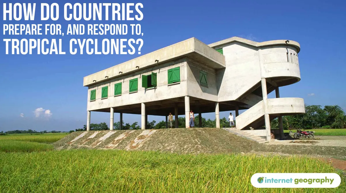
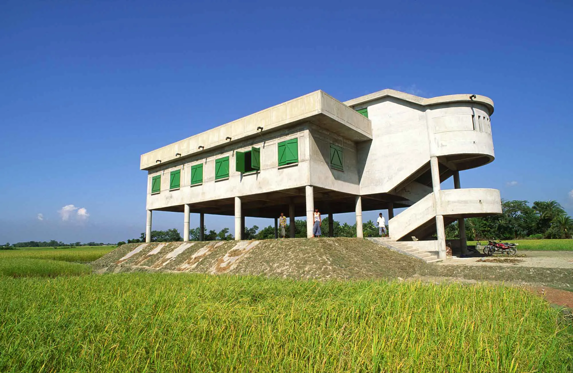
The development and construction of cyclone shelters have had a positive impact on storm survival, dramatically reducing deaths.
Approximately 3,500 cyclone shelters have been built across Bangladesh, which can accommodate up to 5,000 people during a storm. Areas without a shelter can see a 50% increase in death rates. There is no doubt that these shelters are adequate, and more are needed across Bangladesh.
With 400km of low-lying coastline, it is impossible to protect the entire country against the threat of cyclones. However, where possible, efforts have been made to increase evacuation routes by building roads on embankments above the water level.
A cyclone storm shelter in Bangladesh
Measuring Bangladesh’s success:
Warning systems, weather forecasting and shelters have led to a reduction in the death toll and damage caused by cyclones.
However, limited literacy reduces the effectiveness of education and awareness programs – some people do not understand the warning signs. There have also been false alarms, so people tend to wait and see to protect their property. This can lead to devastating consequences if storms move quickly, cutting off evacuation routes.
How do developed countries prepare for tropical cyclones? The USA
Developed countries are still vulnerable to hazards from tropical storms; however, due to advances in technology, they are better equipped to deal with these threats.
Weather forecasting and satellite technology:
With over 20 satellites in operation every day, the USA has regular weather forecasts, which can provide early warning on TV and Radio. Most people have access to a mobile device, with an average of 103 phones per 100 people. This allows warnings of severe weather to reach the majority of the population.
The National Hurricane Centre in Miami issues forecasts and warnings about incoming hazardous weather and provides education to people about tropical cyclones.
However, ageing satellite technology and outdated software prevented the US from providing detailed predictions on Hurricane Sandy’s likely track. The UK’s weather forecasting centre, based in Reading, ultimately provided accurate weather data that was used to prepare New York residents for the impending dangers of the storm. Hurricane Sandy was the second-costliest storm in US history!
Risk zones and evacuation planning
The USA uses detailed risk maps to show which coastal communities are most at risk from storm surges and flooding. These maps are based on elevation, distance from the coast and population density. Areas are divided into different “risk zones”, which helps emergency services decide who should be evacuated first.
Many coastal cities also have evacuation routes that lead away from low-lying areas towards safer ground. In Florida, for example, signposted evacuation highways are designed to move large numbers of people quickly. Emergency services also issue clear evacuation orders through TV, radio and mobile alerts.
The system is effective, but not everyone leaves when told to. Some people stay behind to protect property, while others lack transport or have mobility issues. This means that the most vulnerable community members often require additional support to reach safety.
Storm surges and coastal defences
Storm surges are one of the biggest threats during hurricanes. Following Hurricane Katrina in 2005, the USA invested heavily in new flood barriers and reinforced sea defences. In some areas, beaches have been rebuilt or elevated to withstand powerful waves and mitigate erosion.
Major cities such as New Orleans also rely on river levees — raised embankments designed to stop floodwater from entering low-lying neighbourhoods. However, if these barriers are poorly maintained or overtopped by a large surge, flooding can be devastating. During Hurricane Katrina, damaged levees allowed water to pour into the city, leaving homes and roads underwater for weeks.
As sea levels rise and storms become stronger, the USA continues to enhance its coastal protection, striking a balance between engineering solutions and more natural approaches, such as restoring wetlands and natural sand dunes.
Summary
Forecasting and Tracking
Satellites and radar are used to monitor storms and predict their path, giving vital early warnings before landfall.
Early Warning Systems
Governments send alerts through TV, radio, sirens and mobile phones so people know when to evacuate or take shelter.
Evacuation and Shelters
High-risk coastal areas are evacuated, and people move to cyclone shelters or strong public buildings designed to withstand storms and storm surges.
Coastal Defences
Structures such as sea walls, flood barriers and raised levees protect communities from flooding caused by storm surges and strong waves.
Education and Preparedness
Public awareness campaigns teach people how to stay safe, store supplies, and understand warning messages, reducing casualties.
Response and Recovery
After the cyclone, emergency services rescue survivors, provide medical care and restore power and water. Long-term recovery includes rebuilding homes, roads and services, often with help from international aid.