How can the impacts of river flooding be managed?
Flood hydrographs
Forecasting floods is crucial for protecting lives and assets. Flood hydrographs serve as an instrumental tool in this prediction process. Such a hydrograph charts river discharge (expressed in cubic metres per second or cumecs) and rainfall (denoted in millimetres) against time.
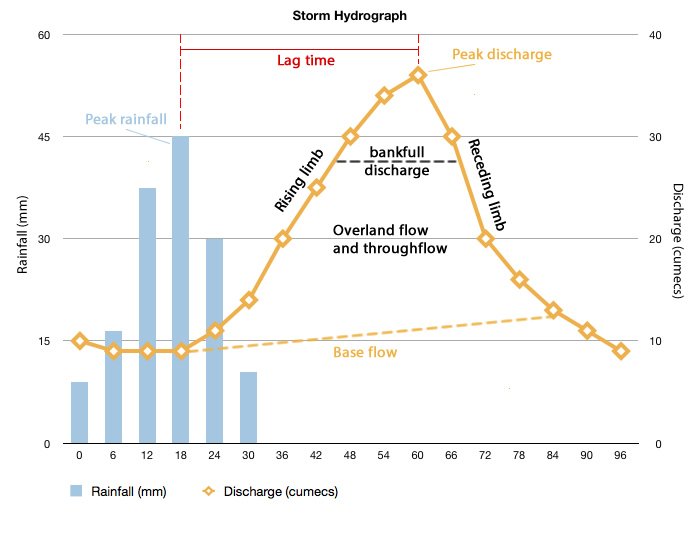
A flood hydrograph
Key elements of a standard hydrograph include:
- The period of heaviest rainfall is called the rainfall peak.
- A section termed the rising limb depicts the increase in river discharge.
- The highest point of discharge is known as the flood peak.
- The falling limb illustrates the declining discharge rate.
- Lag time is the duration between peak rainfall and the flood peak. This interval provides a window for preparations against an impending flood, potentially spanning from hours to weeks in larger rivers. Every river exhibits a distinct flood hydrograph and associated lag time.
Due to short lag times and pronounced flood peaks, some rivers pose significant risks for nearby inhabitants. As an increasing number of individuals settle in floodplains and deltas, the ability to predict floods has become even more vital.
Managing the impacts of flood
Historically, ‘hard engineering’ techniques have been used to tackle flooding. Hard engineering solutions include dams, reservoirs, levées, dredging, and the construction of flood relief channels. Essentially, this involves creating wider, deeper channels, often straighter than the original ones, through methods like dams and levées. While these approaches might decrease flooding in certain areas, they can inadvertently trigger unforeseen issues in other parts of the drainage basin. In contrast, ‘soft engineering’ methods involve strategies such as afforestation, zoning land use, and restoring river systems.
Hard engineering river management
- Dams and Reservoirs:
- Purpose: To store water and regulate river discharge.
- How it works: Dams are large barriers constructed across rivers, holding back water to form reservoirs. This stored water can be released in a controlled manner, helping to prevent sudden increases in river discharge and subsequent flooding downstream.
- Benefits: Provides water supply, hydroelectric power generation, and recreation opportunities. Regulates river flow and reduces downstream flood risk.
- Drawbacks: Environmental impacts on aquatic habitats, the potential for significant damage if the dam fails, and displacement of local communities.
- Man-made Levees:
- Purpose: To increase the capacity of the river channel and prevent flooding.
- How it works: Levees are raised embankments constructed parallel to riverbanks. They contain and elevate the river’s flow, allowing it to carry more water without overflowing.
- Benefits: Protects adjacent land from flooding and utilizes the river’s natural path.
- Drawbacks: If water breaches a levee, it can cause more severe flooding. Over-reliance can lead to underestimation of flood risks.
- Dredging:
- Purpose: To deepen and widen river channels to increase their capacity.
- How it works: Dredging involves removing silt, sand, and other sediments from the riverbed. This process enlarges the river channel, allowing it to hold more water.
- Benefits: Enhanced navigation for boats and ships, reduced flood risk due to increased channel capacity.
- Drawbacks: Can disturb aquatic habitats, may lead to erosion downstream, and the need for regular maintenance as sediment accumulates over time.
- Flood Relief Channels:
- Purpose: To divert excess water away from the main river channel, especially during high-flow periods.
- How it works: These are alternative, man-made channels that run parallel to the main river. When river levels rise to a certain threshold, water is diverted into these relief channels, reducing pressure on the main river.
- Benefits: Reduces the risk of flooding in vulnerable areas by dispersing water over a wider area.
- Drawbacks: Can alter natural water flow and ecosystems. Construction can be expensive and land-consuming.
Each of these hard engineering methods offers solutions to manage and mitigate flood risks but also comes with environmental, social, and economic trade-offs.
Soft engineering river management
- Afforestation:
- Purpose: To increase water uptake and stabilize soil, reducing surface runoff.
- How it works: Planting trees in catchment areas increases the absorption of rainwater, as tree roots take up water and hold the soil together, reducing the speed of surface runoff.
- Benefits: Reduces soil erosion, enhances biodiversity, and acts as a carbon sink.
- Drawbacks: It can take years to establish, might not be suitable for all areas, and may restrict land for other uses.
- Contour Ploughing:
- Purpose: To reduce surface runoff and soil erosion.
- How it works: Ploughing is done parallel to the contours of the land, creating ridges that slow the flow of water downhill.
- Benefits: Reduces soil erosion, retains water in fields, and enhances soil fertility.
- Drawbacks: It can be labour-intensive, unsuitable for very steep terrains, and may limit the use of machinery.
- Terracing:
- Purpose: To convert slopes into stepped, flat surfaces to reduce runoff and erosion.
- How it works: Steep slopes are transformed into a staircase-like structure, with each flat part allowing cultivation and reducing water speed.
- Benefits: Enables agriculture on steep lands, reduces soil erosion, and retains water.
- Drawbacks: Labor and cost-intensive to establish, potential for terrace walls to collapse if not maintained.
- Land Use Zoning:
- Purpose: To regulate and control development in flood-prone areas.
- How it works: Authorities demarcate zones based on flood risk. High-risk zones may be designated as parks or recreational areas, while low-risk zones can be used for buildings and infrastructure.
- Benefits: Minimizes potential damage from floods, guides sustainable development, and protects vulnerable habitats.
- Drawbacks: Can limit economic development, might face opposition from stakeholders, and requires effective monitoring.
- Restoring River Systems:
- Purpose: To revert modified river systems to their natural state.
- How it works: Actions like removing artificial straightening or removing barriers allow the river to revert to its natural meandering path and flow.
- Benefits: Enhances biodiversity, restores natural floodplains, and can reduce flooding downstream.
- Drawbacks: It can be expensive, might face resistance if it affects existing infrastructure, and takes time to achieve desired outcomes.
Soft engineering approaches are generally favoured for being more sustainable and environmentally friendly. They aim to work with nature rather than attempt to dominate or alter it, leading to longer-term solutions with fewer unintended consequences.
Summary
Flashcards
Check Your Knowledge
Coming soon