River landforms – The long profile and shape in cross-section
The long profile of a river
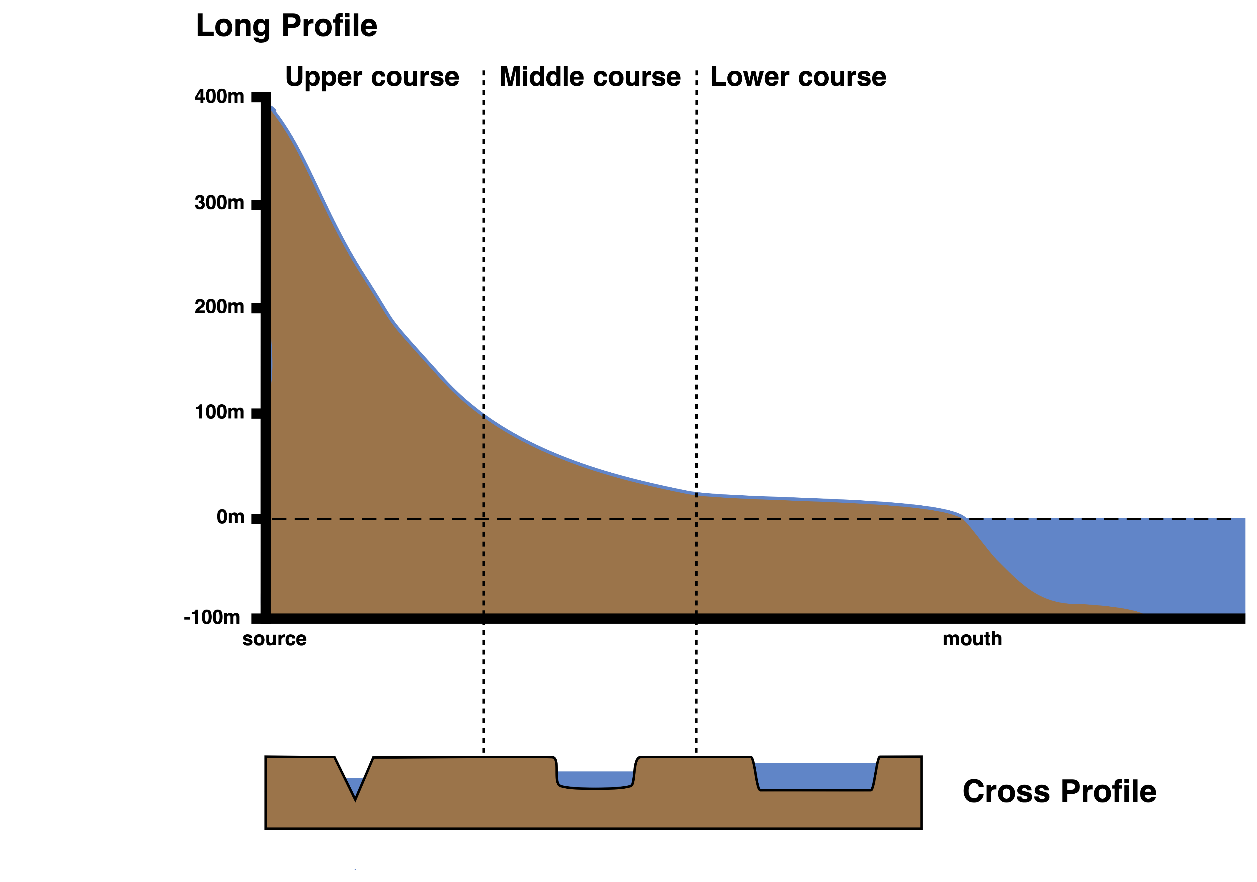
A river’s long profile refers to the gradient or slope of the river from its source to its mouth, typically showing a concave shape as it transitions from steep mountainous areas to gentler plains.
A river’s cross profile, on the other hand, shows a cross-sectional view of the river at a specific point, illustrating the width and depth of the river channel and the height of the valley sides at that location.
Several processes, including weathering and mass movement, contribute to differences in cross and long profiles. Certain irregularities, or “knick-points”, arise due to:
- Geological Factors: Hard rocks erode slower, potentially creating waterfalls and rapids.
- Load Variations: A tributary carrying larger particles might cause the primary valley’s gradient to become steeper.
- Changes in Sea Level: A decrease in relative sea level can trigger further erosion, enabling rivers to reshape old floodplains and create new terraces and knick-points.
Rivers generally aim for a state of balance or equilibrium. They smooth out these irregularities through erosion. This balance between erosion and deposition lets the river adapt based on its capabilities and tasks. This adaptation mainly manifests in the river’s gradient, resulting in a uniform, concave profile.
The long and cross profile of a river
The cross profile of a river
In the upper section of a river, the cross profile typically resembles a ‘V’ shape (see the image above). In this stage, rivers usually have a steep gradient and narrow valleys. These waters are not deep but are swift. Large boulders create significant friction, causing the river to expend much energy. Processes in this segment include vertical erosion, slope weathering, mass movement, and transport. You might spot features like waterfalls, rapids, potholes, gorges, and interlocking spurs.
Moving to the river’s middle course, the valley retains its ‘V’ shape but isn’t as steep. The sides have a gentler slope. Here, the beginnings of a floodplain are evident, and meandering patterns emerge. Processes at play include both vertical and lateral erosion, meandering, transport, and some sediment deposition on the insides of the meanders.
The cross profile is considerably broader and flatter when we reach the river’s lower course. The river engages in erosion (particularly on outer banks), transport, and notably in deposition, especially on the inner meander bends and across the floodplain. Typical landforms in this area include levées, oxbow lakes, floodplains, deltas, and terraces.
Discharge increases from source to mouth as tributaries add water to the main river channel. Velocity also increases from the source to the mouth as there is less friction with the river bed and sides. Therefore, the water flows faster.
Summary
Flashcards
Check Your Knowledge
Coming soon