What are drainage basins and what are their characteristics?
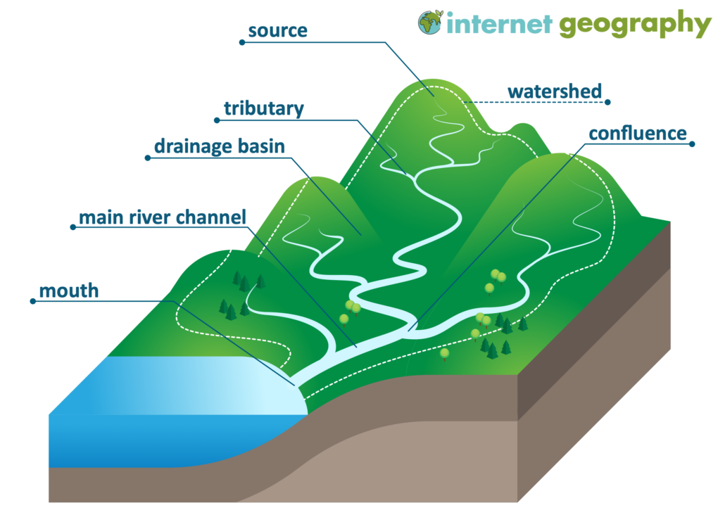
A drainage basin is an area of land drained by a river and its tributaries. Drainage basins are also known as river basins or catchment area. When it rains in this area, the water goes towards the main river, either over the land or underground, and ends up at the river’s mouth. The boundary between two drainage basins is called a watershed. These smaller streams are named tributaries. The point where two streams or rivers join is a confluence. The amount of water flowing in a river is called its discharge. It’s measured in cubic metres per second, often shortened to “cumecs”. The diagram below shows the main features of a drainage basin.
The drainage basin system
Drainage basins are open systems where water can be added as an input and leave the system as an output. Various processes occur within drainage basin systems.
What processes happen in a drainage basin?
Inputs into a drainage basin:
- Precipitation: This is the primary input and can be rain, snow, sleet, or hail.
- Groundwater: Water in the ground can enter the drainage basin from adjacent areas.
Processes that occur within the drainage basin include:
- Interception: Trees and vegetation catch some precipitation before it hits the ground. The rainfall interception by vegetation may protect the soil as intercepted water is released more slowly to the land’s surface.
- Dripflow: Water flowing over leaves, then drips to the ground.
- Stem flow: Water flowing down the stems of trees and plants.
- Infiltration: Water soaks into the soil from the surface. Areas with a low infiltration capacity can be susceptible to flooding after heavy rain as water cannot enter the ground fast enough, increasing surface run-off.
- Throughflow: Water moves sideways through the soil towards the river.
- Surface Runoff (Overland Flow): Water flows over the land, mainly when the ground is saturated or impermeable.
- Percolation: Water moves downwards from the soil into the bedrock under gravity. The percolation rate is affected by how porous the soil or rock is and how permeable the rock is.
- Groundwater Flow: Water flows through the rock below the water table towards the river. Groundwater flow is also known as baseflow. Groundwater appears on the surface as a spring or flows into a river channel. It increases where rock and soil are very porous and permeable during steady rainfall.
- Channel Flow: Water in the river flows towards the river’s mouth.
- Evapotranspiration: Water evaporates from soil and plant surfaces and is transpired by plants.
Storage:
- Aquifers: Water is stored underground in faults, joints, cracks, bedding planes and pore spaces forming aquifers. The top of an aquifer is called the water table. The water table rises and falls depending on the input of water into the aquifer and the volume of water leaving it.
Outputs:
- Discharge: The volume of water leaving the drainage basin through the river channel, usually measured in cumecs.
- Evaporation: Water turns into vapour and returns to the atmosphere.
- Transpiration: The loss of water vapour from vegetation from the stomata of leaves into the atmosphere.
- Percolation to deeper layers: Sometimes, water will go past the drainage basin into deeper underground layers, removing it from the system.
Remember, the balance between inputs, processes, and outputs determines the amount of water in a drainage basin at any given time. The water level will rise if more water enters the system (input) than leaves it (output). The water level will decrease if more water exits the system than enters it.
Summary
Flashcards
Check Your Knowledge
Coming soon

