What factors affect river regimes?
A river regime illustrates the variations in a river’s discharge throughout the year. Several factors influence the regime of a river, including climate, vegetation, geology and soils, land use, and water abstraction and dams.
How does climate affect river regimes?
Climate plays a crucial role in defining a river’s regime:
- For instance, the River Shannon in Ireland, located in a temperate region, exhibits a prominent discharge peak during winter due to the high rainfall commencing in late autumn and tapering off by spring.
- The River Gloma in Arctic Norway shows a spring peak in discharge, which correlates with snow melting as temperatures rise post-winter.
- The River Po, situated near Venice, witnesses two primary peaks in discharge coinciding with periods of heavy rainfall in spring and autumn and the springtime melting of snow from Alpine tributaries.
For river regimes, the form of precipitation is crucial. For example, snow is significant in polar and high-altitude regions, and summer thunderstorms with convective rainfall are pertinent in warm or hot continental interiors. Temperature substantially impacts evaporation rates – high temperatures result in more evaporation, with less water reaching rivers.
However, warm air can hold more water vapour than cold air, potentially resulting in very high levels of precipitation and river discharge.
How does vegetation affect river regimes?
- Dense vegetation cover plays a significant role in intercepting more rainfall, promoting infiltration, and reducing surface runoff. Broad-leaved species are particularly efficient in this regard.
- Deciduous trees shed their leaves during winter, resulting in less intercepted rainfall.
- Wetlands act as natural water storage systems, gradually releasing water into rivers.
How do geology and soil affect river regimes?
- Rocks allowing water to permeate them contribute to groundwater accumulation, slowly seeping into rivers as base flow.
- Soils with high compaction tend to have less infiltration and increased surface runoff.
How does land use affect river regimes?
- Areas covered with forests are highly effective in slowing down water movement to river systems. On the other hand, runoff is quicker in areas devoid of vegetation cover.
- Urban areas, due to their high impermeability, have quick runoff. However, urban drainage systems are designed to remove surface water swiftly.
How do water abstraction and dams affect river regimes?
Water Abstraction and Dams: Water abstraction, which is the process of taking water from rivers for uses such as human consumption, irrigation, and other purposes, is common in most large rivers. It a) directly alters surface water flows and b) indirectly reduces groundwater levels.
Dams control river flow for navigation, irrigation, hydroelectric power generation, and human water supply. The large volumes of water stored behind dams are subject to substantial evaporation, especially in hot and dry climates.
What other factors affect river regimes?
- Size and Shape of Drainage Basin: Smaller drainage basins respond quicker to precipitation events.
- Slope: Steeper terrains lead to increased surface runoff.
- Drainage Density: Drainage basins with high drainage density react more swiftly to storm events.
Storm hydrographs
Storm hydrographs are graphical representations of the discharge of a river over a specific period, typically before, during, and after a storm event. They provide valuable insights into the relationship between rainfall and river flow. Understanding storm hydrographs helps in flood prediction, management, and the various factors influencing how a drainage basin responds to rainfall.
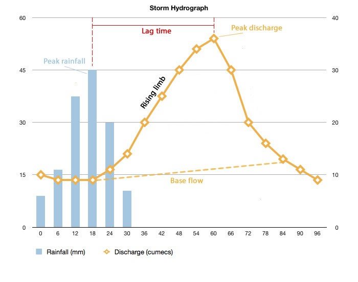
A storm hydrographic
Characteristics of Storm Hydrographs:
- Baseflow: This is the normal day-to-day discharge of the river and represents the groundwater contribution to the river flow.
- Rising Limb: The rising limb is the part of the graph that shows the increase in river discharge following a rainstorm. The steepness of the rising limb indicates how quickly the discharge increases. A steep rising limb might indicate impermeable rock or urban areas where water flows rapidly into the river.
- Peak Discharge: This is the highest point on the graph, representing the maximum discharge of the river following the storm. It’s an essential value in flood prediction.
- Lag Time: Time lag is the delay between peak rainfall and peak discharge. A shorter time lag might suggest a smaller drainage basin or one with steep slopes, where the water reaches the river more quickly.
- Falling Limb: The falling limb represents the decrease in river discharge as the extra water brought by the storm moves downstream or infiltrates the ground. A steep falling limb suggests that water is leaving the drainage basin quickly.
- Recession: This is the return of discharge to its pre-storm level or base flow.
- Peak Rainfall: This is the point at which rainfall is at its highest during the storm, and it’s often represented on the hydrograph to illustrate the relationship between rainfall and discharge.
Factors Influencing Storm Hydrographs:
The characteristics of storm hydrographs can vary widely depending on several factors:
- Drainage Basin Characteristics: Shape, size, slope, geology, land use, and vegetation influence how water moves through the basin.
- Rainfall Characteristics: Intensity, duration, and type of rainfall (e.g., slow-soaking vs. intense thunderstorm) will affect the hydrograph.
- Antecedent Conditions: The existing condition of the basin, such as whether the ground is already saturated from previous rain, will impact the response to further rainfall.
Storm hydrographs are vital tools in geography, helping to illustrate and understand how rivers respond to storm events. They incorporate complex factors integral to flood management and studying hydrological processes in a drainage basin.