
Sakurajima Case Study
This case study has been developed to support students studying Edexcel B GCSE Geography.
Japan is located on a convergent plate boundary where the Eurasian plate is subducted by the Pacific and Philipinnes plates, causing a series of volcanoes.
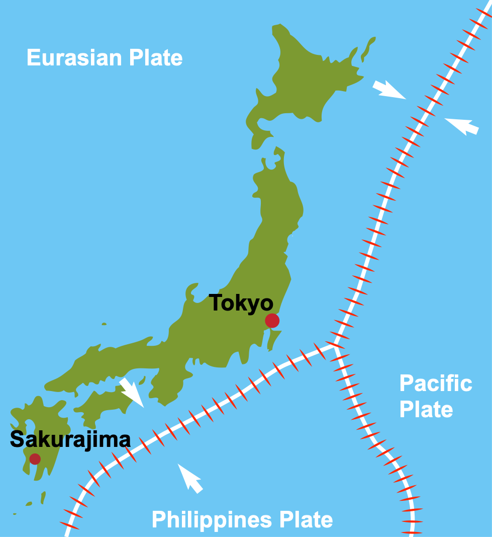
A map to show the tectonic setting of Japan and the location of Sakurajima
Sakurajima, Japan’s most active volcano, is located on the southern island of Kyushu and has erupted since the 1950s, sometimes over 200 times a year. As it is situated on a convergent plate margin, Sakurajima is a stratovolcano formed from layers of lava and ash. Eruptions are explosive, producing large volumes of ash, pyroclastic flows, volcanic bombs and poisonous gases. The lava is andesitic, meaning it has a high gas content and is very viscous (thick).
What are the Primary Impacts of Sakurajima?
The primary effects of a volcanic eruption are those caused instantly. These are directly linked to the type of volcano and eruption.
The primary effects of the Sakurajima eruptions include:
- Approximately 30km³ of ash erupts from the volcano annually, causing damage to crops and electricity lines. To avoid disruption, ash regularly needs to be cleared from urban areas.
- Ash reduces visibility, making roads unsafe for driving. Air travel is also disrupted as ash poses a risk to aeroplane engines.
- Eruptions of lava and ash have destroyed homes and crops in the past.
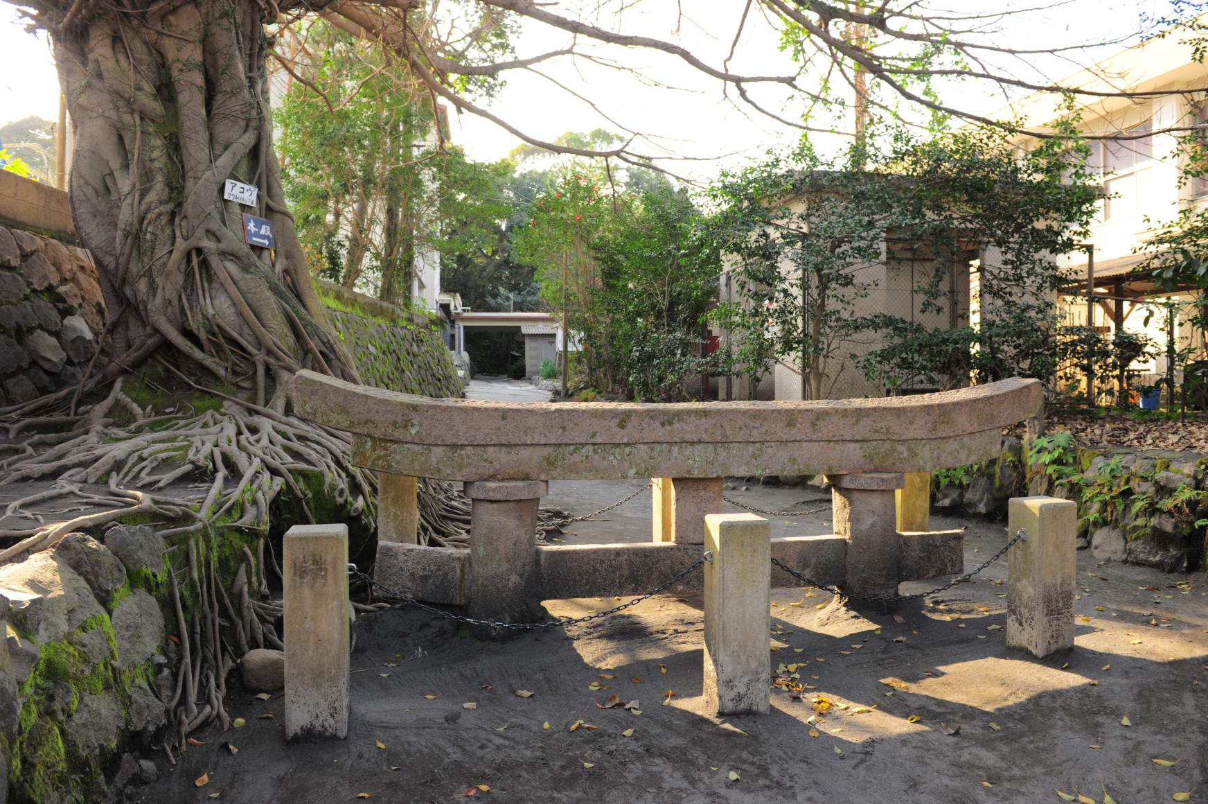
- Lava flows have destroyed croplands and hundreds of homes in the past. The photograph below shows the top of a gate that is 3m tall that was buried by a lava flow in 1914.

The Torii gate of Kurokami Shrine
- Strong earthquakes have occurred during violent eruptions. Fifty-eight people died from an earthquake triggered by Sakurajima’s last major eruption in 1914.
- Shock waves caused by the eruption of Sakurajima have shattered windows over 10km away from the volcano.
- During violent eruptions, volcanic bombs have been thrown over 3km from Sakurajima, cracking car windshields.
What are the Secondary Impacts of Sakurajima?
The secondary effects of a volcanic eruption are those that occur in the hours, days and weeks after an eruption.
The secondary effects of the Sakurajima eruptions include:
- Continual ashfall from the volcano has caused respiratory problems such as asthma.
- Studies have linked volcanic emissions in the area to increased cancer rates.
- Crops have been damaged by acid rain caused by gases emitted by the volcano combined with rainfall.
- The soil around the Sakurajima is very fertile due to its volcanic soil. This has supported the growth of the tea and rice industry in Kagoshima, the region overlooked by the volcano.
- The area is a major tourist destination due to the volcano, its national park status, scenery and hot springs. This has brought money to the area and has created many jobs.
How are Sakurajima’s Hazards Managed?
Management of volcanic hazards includes short-term relief (shelter and supplies) and long-term planning (trained and funded emergency services), preparation (warning and evacuation; building design) and prediction.
Japan is a developed country; therefore, it can afford to finance monitoring, protection and evacuations.
Short-term relief
Residents local to Sakurajima are instructed to evacuate when alert levels are raised. For example, in 2015, residents closest to the volcano had to evacuate when alert levels were increased to four (out of five). Evacuation cards were issued so the authorities could monitor who had evacuated and where they had evacuated.
Ash bags are issued to residents during periods of high ashfall to remove ash from their properties, including roofs and pavements. The bags are then collected from residential ash collection areas by the council and disposed of.
Residents wear masks and close windows during periods of high ashfall. In addition, during periods of high activity, areas close to the volcano are declared off-limits to tourists and residents to protect people from poisonous gases and volcanic bombs.
People use the concrete lava bomb shelters around the volcano to protect themselves from being hit by material ejected from the volcano during unexpected eruptions.
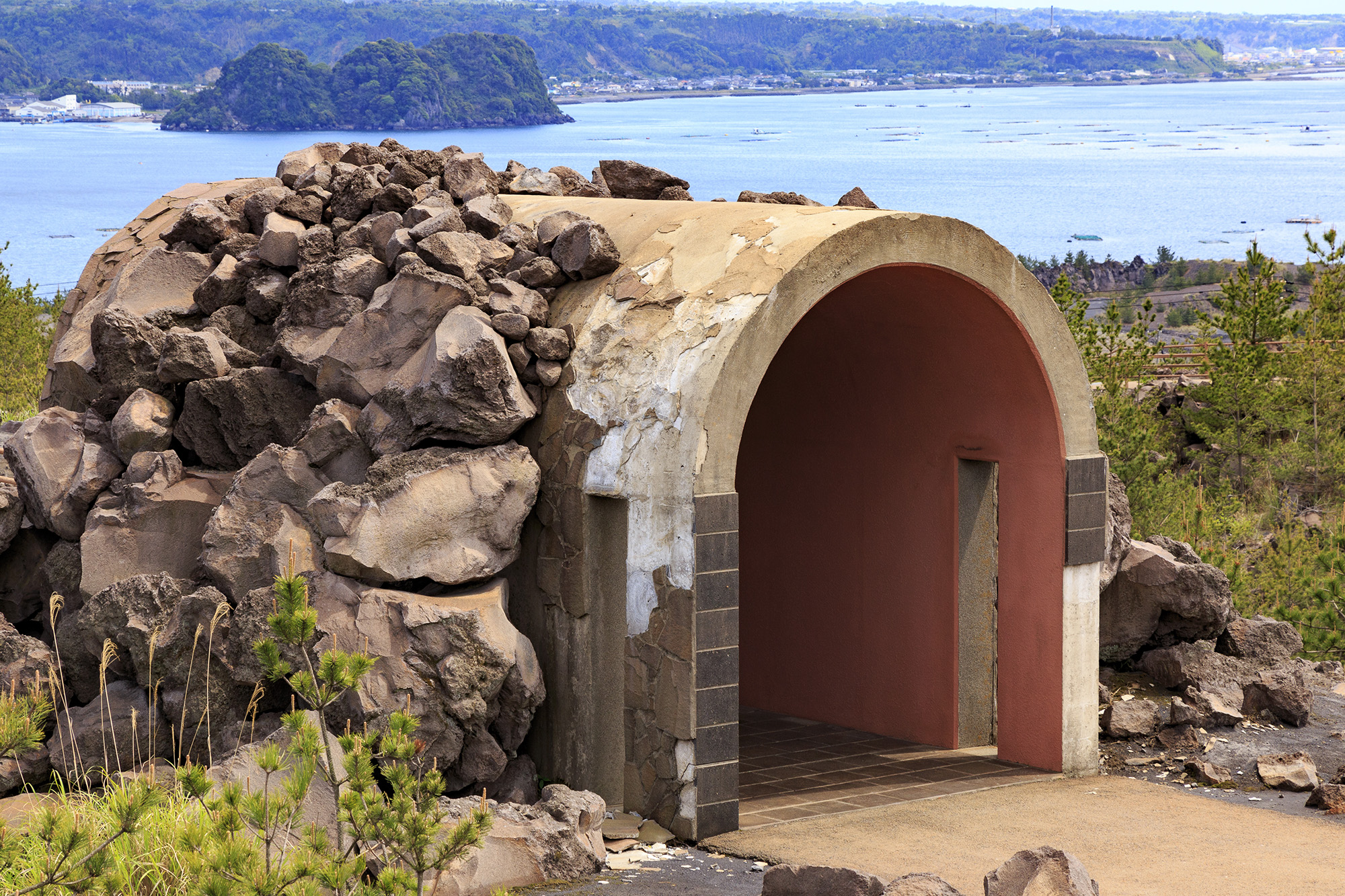
A lava bomb shelter close to Sakurajima
Long-term planning
Preparation
Several shelters have been constructed to offer protection during and after eruptions. These are signposted so people can get to them quickly.
Concrete channels have been constructed to divert volcanic mudflows, known as lahars, from developed areas.
A warning scale of 1-5 has been developed, so people know when to evacuate. In addition, local people have been directed to have evacuation kits available that include hardhats to protect people from volcanic material.
Planning
There are annual disaster drills for residents and emergency services to practice evacuation. In addition, a 2km zone surrounding the volcano has been established that prohibits people from getting too close.
An evacuation plan has been developed and shared with local people, so they know the procedures they must follow during an eruption, including which ports to use for evacuation.
Prediction
The volcano is closely monitored to that eruption predictions can be made. Gas levels are monitored by aircraft above Sakurajima. When gas levels are high, this can indicate an eruption is imminent. Seismometers are used to measure earthquakes associated with rising magma, and tiltmeters monitor the shape of the land for any bulges or ground swelling, signs of rising magma.


Related Topics
Use the images below to explore related GeoTopics.