What are depressions?
A depression, a low-pressure system, is a meteorological phenomenon characterized by low atmospheric pressure at its centre. Depressions are often associated with unsettled weather conditions, including clouds, rain, and windy conditions that affect the UK. Around 100 depressions pass over the UK, moving in an easterly direction, each year.
Depressions are formed over the Atlantic Ocean by the meeting of two different air masses, typically a warm air mass and a cold air mass. The two air masses do not normally mix due to their temperature and density. The boundary between two air masses is known as a front. When the warm and cold air interact:
- The lighter, warm air is forced to rise over the denser, cold air.
- As the warm air rises, it cools, and the water vapour within it condenses to form clouds and possibly precipitation like rain or snow.
- The rising air creates a centre of low pressure below, which leads to the winds spiralling inward, generating the typical characteristics of a depression.
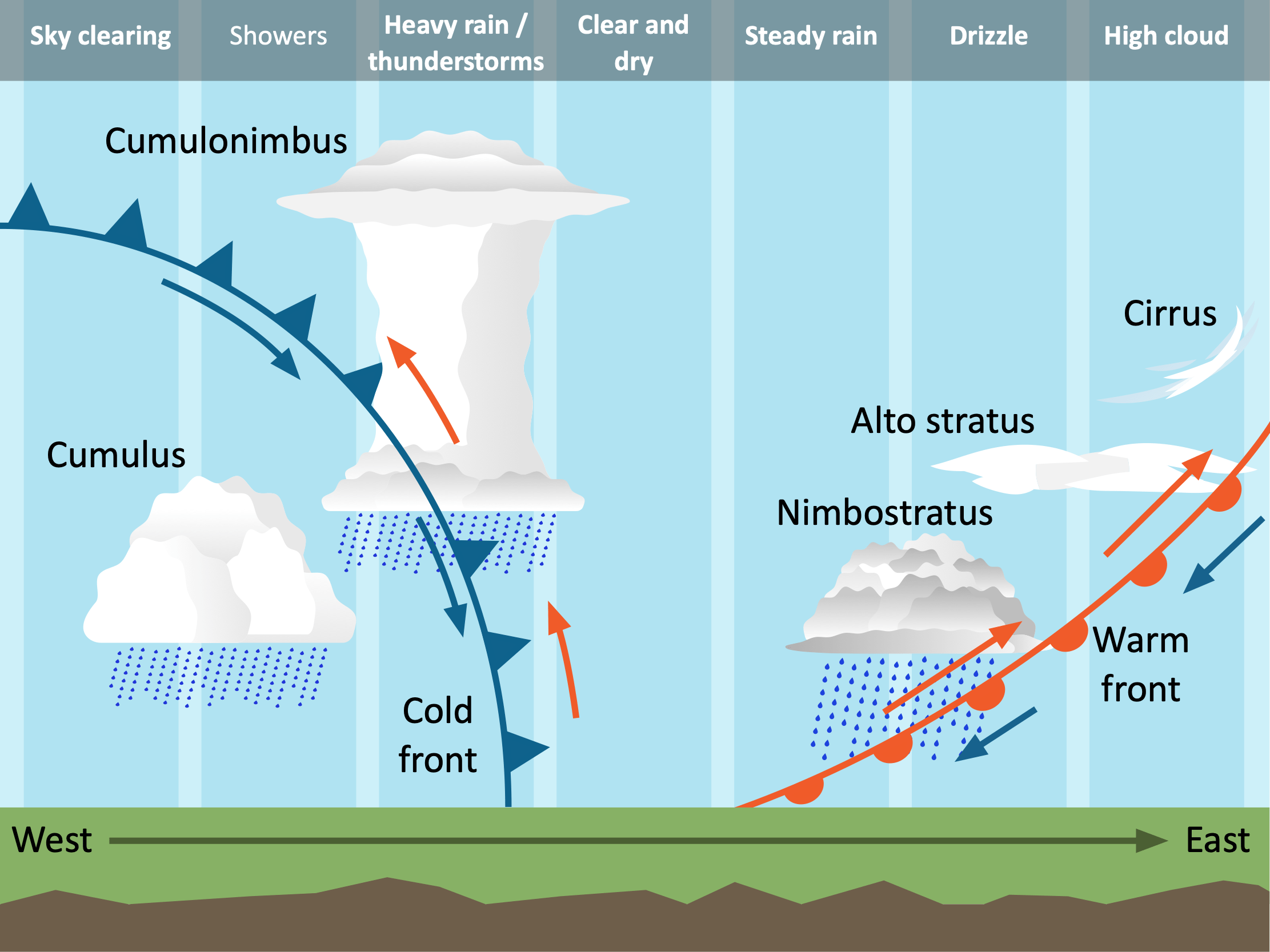
A cross-section of a depression
Depressions – Warm Front
The warm front is typically the first to pass over regions like the UK. This occurs when a warm air mass encounters a cold one. Being lighter, the warm air rises above the cold air, forming nimbostratus clouds. These clouds create a distinct band across the sky, resulting in steady, continuous rainfall. The image below depicts how a warm front forms.
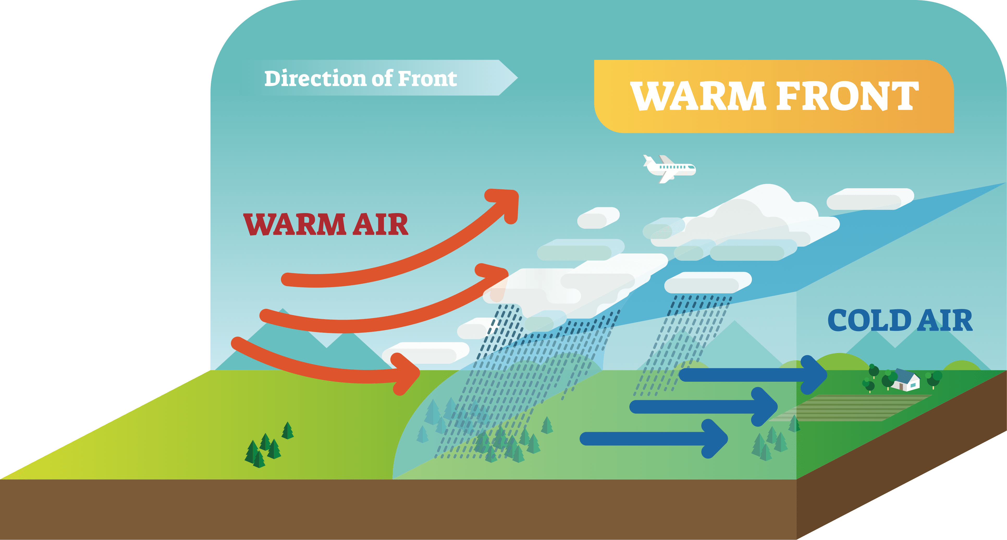
The characteristics of a warm front
Depressions – Cold Front
Following the warm front, the cold front passes over. In this scenario, a cold air mass meets a warm one, with the cold air forcing the warm air to rise rapidly. As the warm air is quickly pushed upward, it cools and condenses, forming towering cumulonimbus clouds. These clouds are associated with heavy rain showers, often brief but intense. The image below illustrates the formation of a cold front.
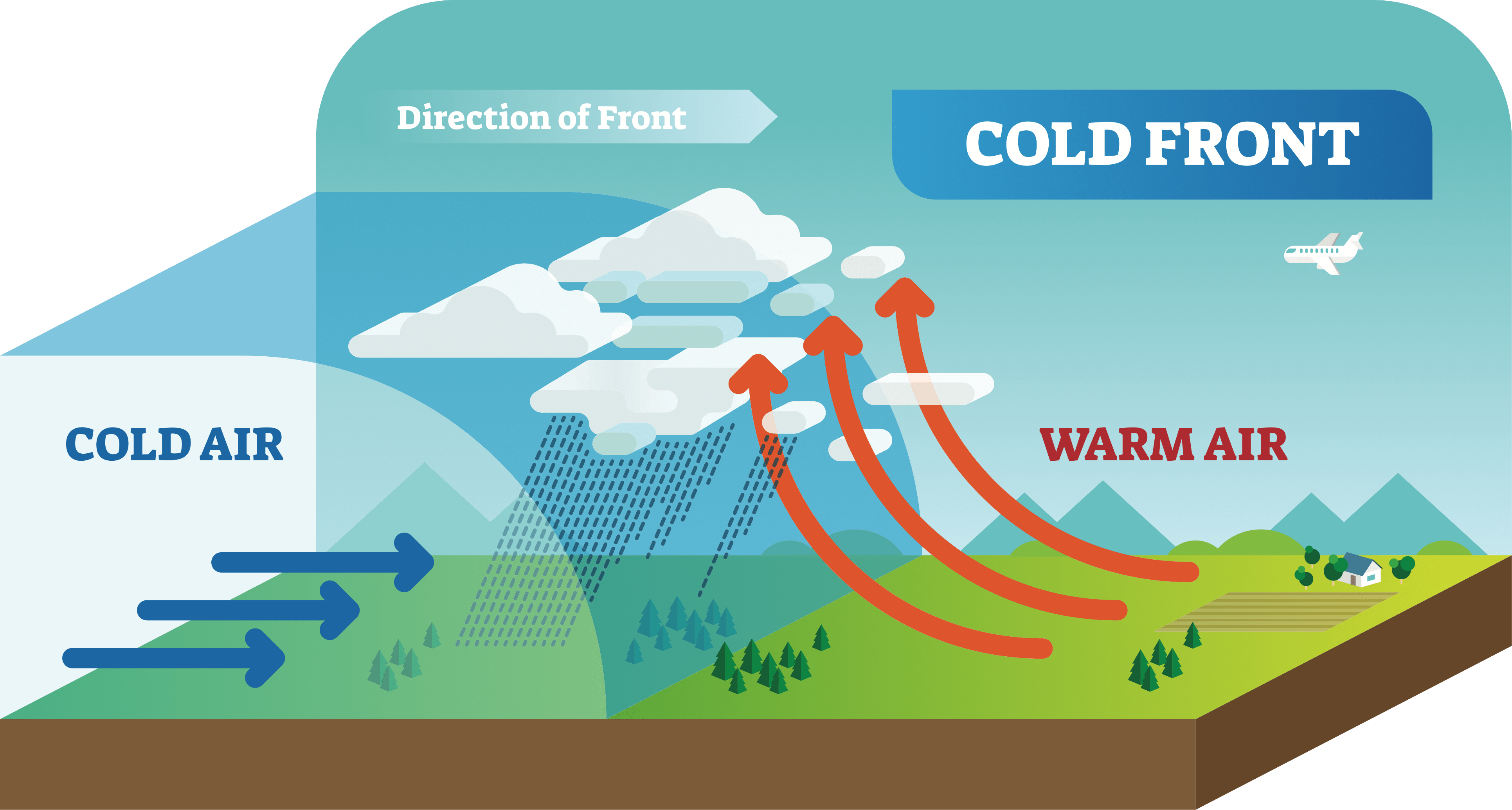
The characteristics of a cold front
How can depressions be identified on a synoptic chart?
On a synoptic (weather) chart, depressions can be identified through several features:
- Isobars: These are lines that connect points of equal atmospheric pressure. In a depression, the isobars are usually closely spaced, indicating strong winds. The isobars might also display a pattern showing decreased pressure towards the centre.
- Fronts: Depressions often exhibit weather fronts, both warm and cold. These fronts represent the boundaries between air masses and are often marked on synoptic charts.
- Weather Symbols: Specific symbols representing cloud cover, rain, wind, and other weather conditions often cluster around the area of a depression.
- Pressure Values: A low-pressure value at the centre, usually lower than 1000mb, is another key identifier.
The synoptic chart below shows a depression approaching the UK.
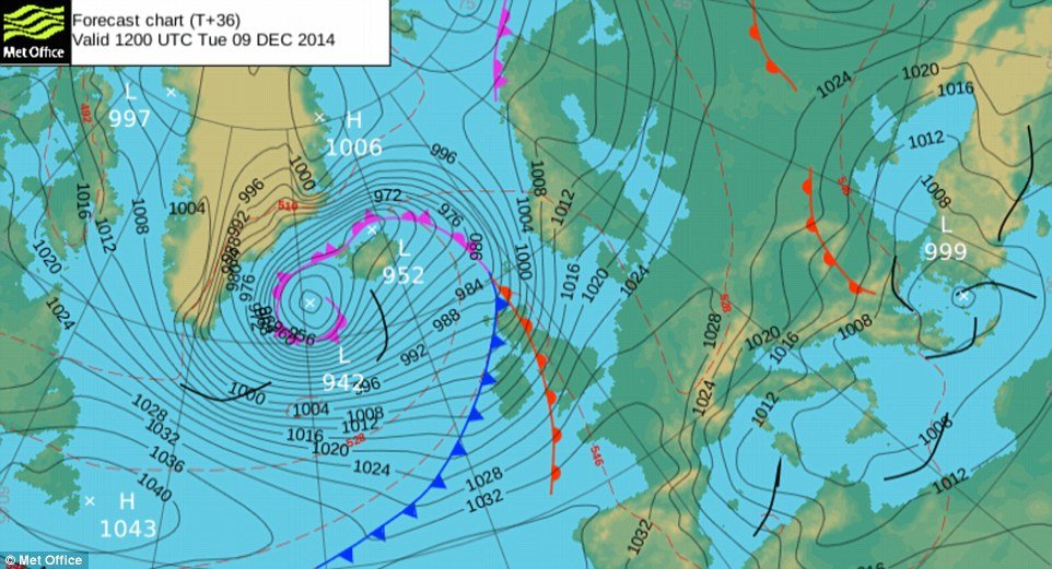
A depression over the UK
An occluded front is formed when the cold front catches up to the warm front. The purple line on the synoptic chart above shows this. An occluded front brings very unsettled weather due to the air mixing. Occluded fronts bring powerful winds and sudden downpours of heavy rain.
What are the key characteristics of a depression?
- Isobars: The presence of closely packed isobars signals strong winds from a quick shift in air pressure.
- Wind: Within a depression, winds circulate in an anti-clockwise direction and align with the isobars. The wind’s course can be determined by tracing the isobars anti-clockwise.
- Rain: A warm front within a depression typically leads to steady, continuous rain as warm air gradually ascends over the cooler air. Conversely, cold fronts cause heavy rain, as the colder air forces the warm air to rise sharply.
- Temperature: The temperature within a depression varies, with the warm sector generally bringing milder temperatures while the cold sector leads to chillier conditions.
Summary
Flashcards
Check Your Knowledge
Label the cross-section of the depression to show its main features.