The Holderness Coast
The Holderness Coast is Europe’s fastest eroding coastline.
Looking for information on the landforms of erosion and deposition on the Holderness Coast? You can find it here.
The Holderness Coast is located on the east coast of England. It extends 61km from Flamborough in the north to Spurn Point in the south.
Lost settlements on the Holderness Coast
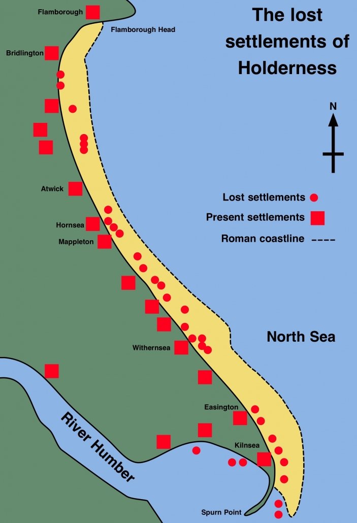
The Holderness Coastline is one of Europe’s fastest eroding at an average annual rate of around 2 metres. This is around 2 million tonnes of material every year. Approximately 3 miles (5kms) of land has been lost since Roman times, including 23 towns/villages. These are shown on the map below.
Underlying the Holderness Coast is bedrock made up of Cretaceous Chalk. However, in most places, this is covered by glacial till deposited over 18,000 years ago. It is this soft boulder clay that is being rapidly eroded.
There are two main reasons why this area is eroding so rapidly. The first is the result of the strong prevailing winds creating destructive waves. The second is that the cliffs are made of soft boulder clay, which erodes rapidly when saturated.
The Holderness Coast is a great case study for examining coastal processes and their associated features. This is because the area contains ‘textbook’ examples of coastal erosion and deposition. The exposed chalk of Flamborough provides examples of erosion and features such as caves, arches and stacks. Coastal management at Hornsea and Withernsea are examples of hard engineering solutions to coastal erosion. Erosion at Skipsea illustrates the human impact of erosion in areas where coastlines are not being defended. Mappleton is an excellent case study of an attempt at coastal management, which has a negative impact further along the coast.
Spurn Point provides evidence of longshore drift on the Holderness Coast. It is an excellent example of a spit, a depositional landform. Around 3% of the material eroded from the Holderness Coast is deposited here annually.
Find out more about the landforms of coastal erosion and deposition on the Holderness Coast.


Use the images below to explore locations along the Holderness Coast.


