Coastal Erosion at Hemsby: A Battle Against Nature

Coastal Erosion at Hemsby: A Battle Against Nature

Coastal erosion is a natural process that happens worldwide, but it has become a pressing issue for the residents of Hemsby, a village on the Norfolk coast. So, buckle up as we explore the science behind coastal erosion, how it’s impacting Hemsby, and what’s being done to fight it.

What is Coastal Erosion?

First, let’s understand what coastal erosion is all about. Coastal erosion is the wearing away of the land by the sea, often involving destructive waves wearing away the coast.

Coastal erosion is a natural process that shapes and reshapes the world’s shorelines. However, human activities, like building structures near the coast or interfering with natural habitats, can speed up erosion or worsen it.

The Hemsby Situation

Hemsby, located on the Norfolk coast in the UK, has been struggling with coastal erosion for quite some time. The village has a beautiful stretch of sandy beach that attracts tourists and provides a livelihood for local businesses. However, the coastline has steadily disappeared, putting homes and businesses at risk.

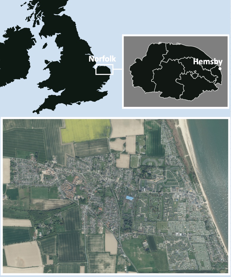
The Location of Hemsby

The Location of Hemsby

The village has lost about 70 meters of coastline in the last 50 years. But the erosion has become even more severe in recent years, with storm surges and high tides causing rapid damage. In March 2018, a powerful storm known as the “Beast from the East” battered the coast, causing seven homes to fall into the sea.

The Impact on Hemsby

Coastal erosion is not just about losing land – it also affects the people living and working in Hemsby. The community’s stability is shaken as homes and businesses are threatened. Moreover, the tourism industry, a crucial part of Hemsby’s economy, could take a hit if the beautiful sandy beaches disappear. About 90% of Hemsby’s economy depends on tourism.

March 2023


In the last few weeks, five homes have been demolished at Hemsby. Recent erosion on the coast has led to several properties built on sand dunes in the village of Hemsby, teetering on the edge and part of an access road being washed away. High spring tides (3.7m) and strong winds (50 mph) have battered the coastal stretch at The Marrams during the last two weeks.

One property was 20ft (6.1m) from the cliff edge a week before the high tides and strong winds, and then there was just 3ft (0.9m).

Demolition work by Great Yarmouth Borough Council is taking place on the north side of Hemsby Gap – a break in the dunes used by lifeboat crews to access the beach.
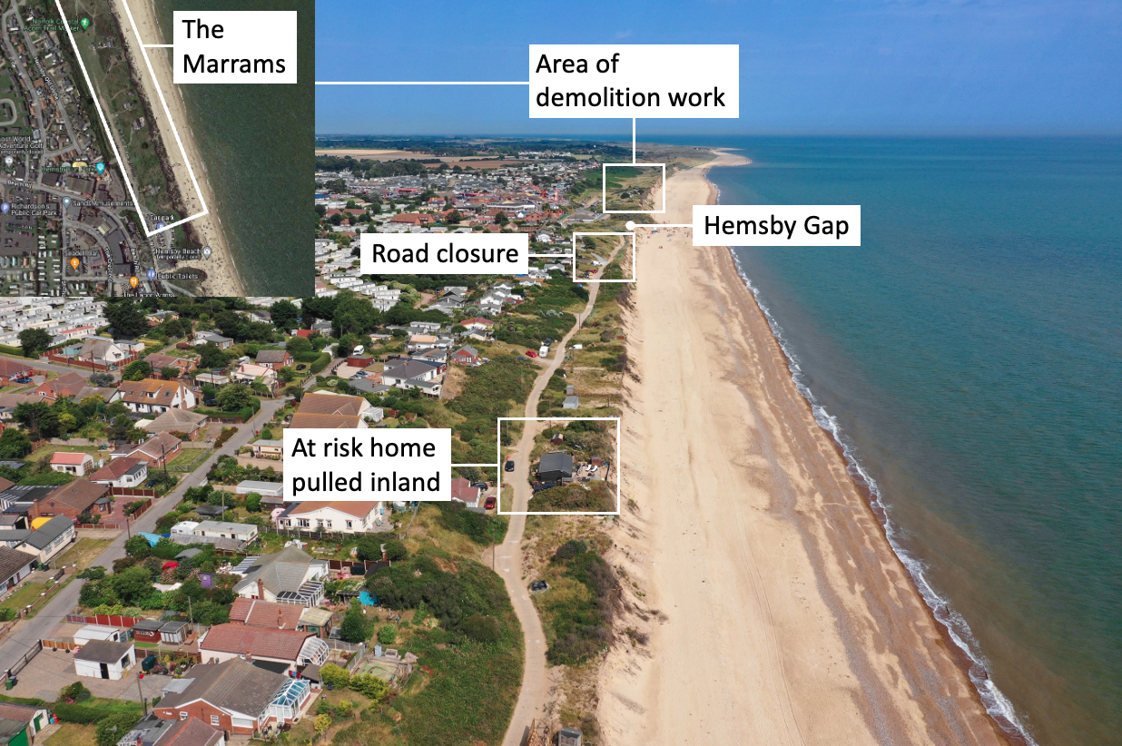
Coastal erosion at Hemsby - photograph taken in July, 2019.

Coastal erosion at Hemsby – photograph (© Internet Geography) taken in July, 2019. Satellite image from Google Maps.

Timeline 

25th February 2023 – The beach at Hemsby was closed because of significant erosion 

10th March 2023 – At-risk homes were evacuated due to fears properties could topple over the cliff. A high tide led to a playhouse and shed falling over the cliff. 

11th March 2023 – The first home was demolished.

12th March 2023 – Two more homes were demolished

13th March 2023 – Two more homes were demolished. 

15th March 2023 – The access road to the south of Hemsby Gap closed due to its collapse

16th March 2023 – One homeowner managed to get his property moved from the cliff edge

What is being done to protect Hemsby?

About 2,000 tonnes of granite rock armour is being added to the beach south of Hemsby Gap as a temporary solution to protect clifftop road access to several properties. Great Yarmouth Borough Council sought permission from the landowner to put granite rocks on the beach. The granite blocks will break the waves and absorb their energy.

Hemsby Lifeboat coxswain Daniel Hurd told the BBC the current situation could have been resolved earlier.

He said: “I just think it’s absolutely ridiculous, this has been an emergency for years and it’s taken this weekend for them to see it’s an emergency to then get a rock berm put on the beach.”

The council responded saying it was a “real minefield of making sure that what local government and the authorities do is the correct line of procedure”.

Noel Galer, Great Yarmouth Borough councillor for East Flegg ward, which includes Hemsby, told Sky News people will be “trying very hard” to look after those who have lost their homes.”Some people literally have a second home which happens to be very close to the beach.

“Perhaps they knew the risks and understood the risks, accepted the risks.

“Others for various reasons may have found this is the only place they can find to live because of the cost and their circumstances and may not be so aware of what’s going on.

“They may have felt there’s no way this is ever going to be washed away.”

He said there used to be two further rows of dunes and that there is a footpath on the local map which goes out to sea.

Following the demolitions, four hundred people attended an emergency meeting in Hemsby to discuss action to help protect the village’s crumbling coastline. The Hemsby Independent Lifeboat and Save Hemsby Coastline organised the meeting. The group have started a petition to get the government to take responsibility to help save Hemsby’s coastline, residents were invited to join a protest outside Westminster or Downing Street in the future, and a “war chest” to fund legal assistance had opened.

The High Seas Treaty

Food shortages in the UK

Seasonal food refers to the times of the year when the harvest or the flavour of a given type of food is at its peak. This is usually the time when the item is harvested. Before supermarkets, most food eaten in the UK was sourced in the UK and seasonal. Fruit and vegetables were available according to the season. For example, during the summer months, lettuce and strawberries were widely available, whereas, during the winter, parsnips and cabbage were sold. Food was also preserved by being bottled, frozen and pickled.

Today, we are used to enjoying seasonal fruit and vegetables throughout the year. However, because some food cannot be grown throughout the year in the UK, it has to be imported from other countries, along with food that is not native to the UK, such as avocado and mango. Therefore, there has been an increase in food being imported into the UK.

According to the British Retail Consortium (BRC), a trade group, UK supermarkets import 95% of their tomatoes and 90% of their lettuce in December and typically import the same proportions in March.

Why is fresh food in the news?

Three big supermarkets in the UK have restricted how much fresh food people can buy, such as tomatoes, cucumbers, and peppers. This is because they want to ensure enough food for everyone and don’t want the shelves to be empty. We don’t know yet if other shops will also have restrictions or if there will be a shortage of other types of food.

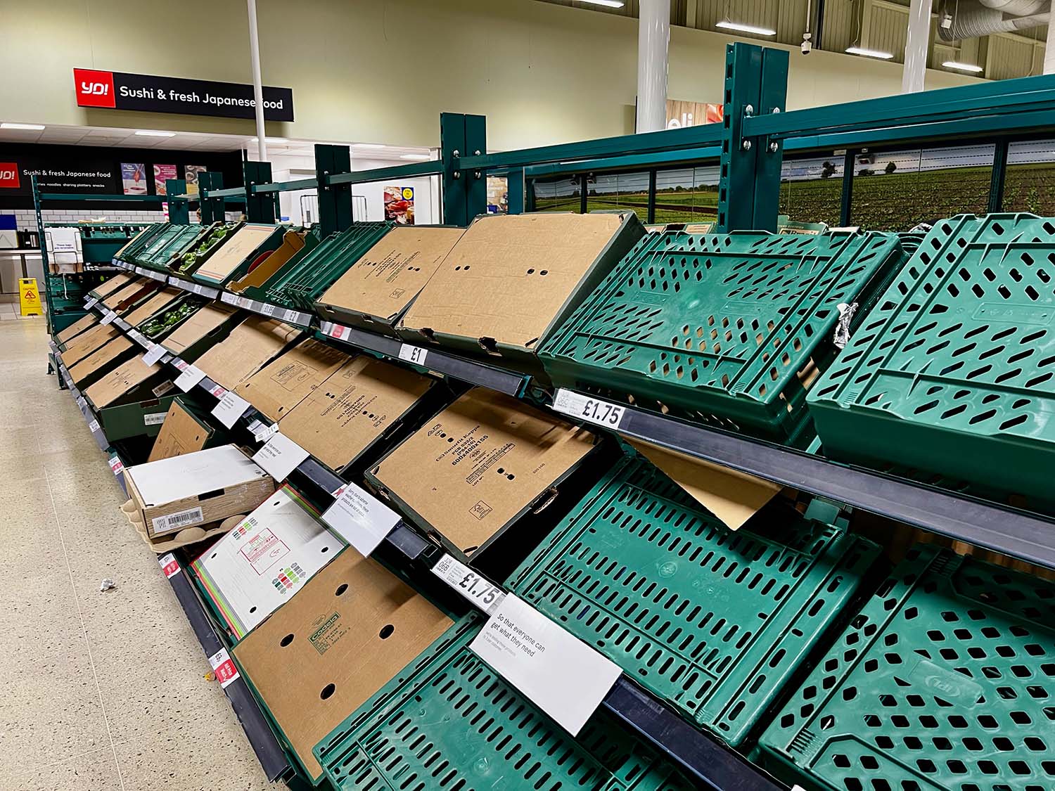
Fresh food shortages in UK supermarkets

Fresh food shortages in UK supermarkets – Empty shelves in Tesco.

How big is the problem?

Morrisons and Asda supermarkets in the UK have restricted how much fresh food people can buy. Morrisons says people can only buy two packs of tomatoes, cucumbers, lettuce and peppers, and Asda says people can only buy three packs of broccoli, cauliflower, raspberries, and lettuce. On Wednesday, Tesco and Aldi said people could only buy three packs of peppers, cucumbers, and tomatoes. Other supermarkets haven’t said anything yet, but some people think there might not be enough food for a few weeks.

What is behind the shortages?

Getting fresh fruits and veggies in the UK is becoming harder because of two problems. First, the weather in Europe and North Africa has been bad, so there isn’t as much food to import. Second, it costs more for UK and Dutch farmers to grow their crops in greenhouses because of higher energy bills, and they planted less food this winter. This means there’s not as much food in the UK, and stores have to rely more on getting food from Spain and north Africa, which were also hit by bad weather. This has led to a shortage of some types of fresh food.

Are things worse in the UK than the rest of Europe?

It seems like France and Germany aren’t having the same problems as the UK when it comes to getting enough food. There’s not as much fresh food in the UK because the weather hasn’t been good, and British farmers aren’t producing as much as usual. This means there’s not enough food, and stores have to ration how much people can buy. The National Farmers’ Union president says there might be even more rationing if the farmers have to pay high energy bills. Some farmers also waited to plant their crops because they weren’t sure it was a good idea with all the problems. It will take a few weeks before the UK can make enough food to fill in the gap. This means stores have to buy food from Spain and Morocco, but there’s not enough to go around, so stores might not have as much food as they need and might have to pay more for it.

So is Brexit to blame?

Many farmers and suppliers don’t think that the UK leaving the EU is the only reason why there’s not enough food in stores. However, some farmers say that Brexit and the pandemic have made things harder because they have to pay their workers more because there aren’t enough. Some people who bring food into the UK from other countries say that Brexit has made it harder to get it here on time because of more paperwork and higher costs. This is especially difficult for food that goes bad quickly and must be moved quickly.

What other food stuffs might run short?

Salad foods like cucumbers, tomatoes, and lettuce are hard to find now. It’s also tough to get aubergines, lemons, broccoli, and lettuce from Spain. In the UK, frost damaged crops like cabbage and cauliflower. But that’s not all. There’s also a shortage of eggs because of a bad bird flu outbreak. All the birds must be kept inside, making it expensive to keep them warm and lit. So, there aren’t as many eggs being made in the UK as usual. One big supermarket, Sainsbury’s, has had to get eggs from Italy because there aren’t enough in the UK.

What could be done to help the situation?

The National Farmers Union wants the government to help British farmers who rely on energy. The president, Minette Batters, thinks it’s unfair that botanical gardens with large glasshouses get help with their energy bills, but food producers with greenhouses don’t. The farming minister, Mark Spencer, says the government is looking into this.

Even though salad crop prices are increasing, farmers might not make more money because they have contracts with supermarkets and suppliers that set prices. Some farmers are upset because supermarkets sell food too cheaply, below its cost. But supermarkets don’t want to raise prices too much and lose customers during the cost of living crisis.

The 2023 Turkey Syria Earthquake

We’re collating resources to support teachers covering the recent devastating earthquake in Turkey. First and foremost, we’ve shared links to anyone who can support NGOs working to help those affected. Additionally, there are links to support teachers in sensitively delivering events such as the earthquake, including advice on supporting the young people affected.

Earthquake Relief

There are many aid agencies providing support to those affected by the recent earthquake that has affected tens of thousands of people in Turkey and Syria, including:

Please email us if you are aware of other aid agencies providing support or can provide a link for donations to aid agencies.

Support

Teachers

Below we have included links to websites that support teaching events such as this in a considered way. After all, many children from Turkey and Siria are being educated in schools outside of the country and may be in one of your classes.

Primrose Schools

Blog – Teachers Pay Teachers

Supporting young people during the initial response to a disaster

Media

Warning – Some of these videos contain footage you may find distressing.

Sky News – Devastation from Above – An aerial view of the Turkey-Syria earthquake

News Links

BBC

BBC News Turkey – Syria Earthquake Home

Turkey earthquake: Screaming, shaking… how it felt when the quake hit

Turkey earthquake: Where did it hit and why was it so deadly?

Turkey earthquake: Why did so many buildings collapse?

Turkey-Syria earthquake: Fire at Iskenderun port extinguished

Syria: Rescuers search for earthquake survivors in Harem

Turkey earthquake fault lines mapped from space – BBC News

Turkey-Syria earthquake: UK aid appeal raises more than £50m

Turkey quake: President Erdogan accepts some problems with response

Turkey earthquake rescue efforts disrupted by security concerns

Turkey earthquake: Roman-era castle destroyed by quake

Turkey earthquake: Hope as foreign help arrives in quake-ravaged Antakya

US pledges $85m for Turkey-Syria earthquake relief


The Economist (requires a free account)

What made the earthquake in Turkey and Syria so deadly?


The Guardian

The Guardian – Turkey – Syria Earthquake Home

Turkey and Syria earthquake devastation – in pictures

Tuesday briefing: Why the Turkey and Syria earthquake was a catastrophe

Before and after satellite images show scale of earthquake destruction in Turkey

Turkey earthquake death toll prompts questions over building standards

Istanbul stock market shuts to prevent selloff after earthquake


Sky News

Sky News Turkey – Syria Earthquake Home

Turkey-Syria earthquake: Which countries have offered to help and what aid are they providing?

Turkey earthquake: Strong, shallow and beneath a highly-populated area – this is the worst kind of quake

Turkey and Syria earthquake: Why have so many been killed, and will it be difficult to get aid to the right places?

Podcasts

BBC Science in Action – Turkey-Syria Earthquake

Twitter

Wind generated a record amount of electricity in 2022

Offshore Wind Farm in the UK

Wind-generated a record amount of electricity in 2022

In 2022, Great Britain generated a record amount of electricity from renewable and nuclear sources, exceeding the amount produced from fossil fuels such as gas and coal. This marks the second-highest level of renewable electricity generation after 2020. The switch to green power is a crucial way to combat the negative effects of climate change.

Renewable energy sources like wind and solar are also becoming increasingly cost-effective, which could result in lower electricity bills over time. While gas remained the primary source of electricity in 2022, according to the National Grid Electricity System Operator (ESO), electricity from wind turbines increased in importance. Overall, 48.5% of electricity in Great Britain came from renewable and nuclear sources, while 40% came from gas and coal.

On a single day in November, wind power produced more than 70% of electricity, or around 20GW. This energy is sufficient to heat approximately 1700 homes a year. The record was broken again on December 30th, when wind turbines generated 20.918GW of electricity.

During five months (February, May, October, November and December), more than half of electricity came from zero-carbon renewable and nuclear sources. The use of coal, the most polluting fossil fuel, also declined, accounting for only 1.5% of electricity in 2022 compared to 43% in 2012.

Despite the increased capacity for renewable energy, the 2015 ban on onshore wind has limited the country’s capacity to increase wind power faster. In December 2022, Prime Minister Rishi Sunak agreed to relax restrictions that effectively prevent onshore wind turbines.

Despite concerns about climate change, the UK approved the first new coal mine in 30 years and opened a new licensing round for companies to explore oil and gas in the North Sea.

The impact of Russia’s war in Ukraine on energy supplies and pricing, as well as sanctions imposed on Russia, a major supplier of gas to Europe, also affected nations like Germany, Spain, Italy, and the US, leading to an increase in renewable capacity.

Beyond 8 Billion – The Ageing Population Crisis in Japan

Afghanistan Earthquake 2022

Introduction

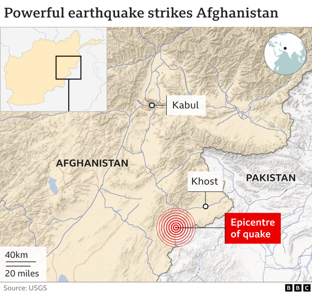
At least 1,036 people have died, and another 2,949 were injured in an earthquake that struck Afghanistan’s Paktika province on the morning of Wednesday 22nd June 2022. The earthquake struck about 44km (27 miles) from the south-eastern city of Khost shortly after 01:30 local time (21:00 Tuesday GMT), when many people were asleep at home.

Afghanistan earthquake map

Afghanistan earthquake map
Source – https://www.bbc.co.uk/news/world-asia-61890804

What caused the Afghanistan earthquake?

Earthquakes are common in Afghanistan’s mountainous province of Khost — nearly 50 have been recorded over the past five years, according to the US Geological Survey.

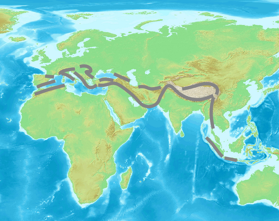
Afghanistan is earthquake-prone because it is located on the Alpide belt, the second most seismically active region in the world after the Pacific Ring of Fire.

The Alpide Belt

The Alpide Belt

The Alpide belt runs about 15,000 kilometres, from the southern part of Eurasia through the Himalayas and into the Atlantic. Along with the Hindu Kush, it includes a number of fold mountain ranges, such as the Alps, Atlas Mountains and the Caucasus Mountains. It has been formed by the collision of a number of tectonic plates.

The Arabian, Indian and Eurasian tectonic plates meet In Afghanistan and create earthquakes when they shift against each other at their borders. The boundary between the Indian and Eurasian plates exists near Afghanistan’s border with Pakistan.

The earthquake in Afghanistan formed when the Indian plate crashed violently with the Eurasian plate. Collisions like this shake and squeeze the ground upwards. Along with causing earthquakes, this movement creates mountains like the Himalayas or the Hindu Kush and Pamir mountain ranges in northeast Afghanistan.

What were the effects of the Afghanistan earthquake?

The most recent figures put the death toll at 1,150 people with at least 1,600 injuries. The number of dead and injured is expected to rise as remote areas are reached and rescue workers are able to search collapsed buildings.

The earthquake destroyed critical infrastructure — including homes, health facilities, schools and water networks.

In the areas that have been accessed so far, as many as 1,900 homes have been destroyed including 1,028 in Giyan, 450 in Barmal and 416 in Spera. Many homes had large families of seven or more people, so the number of people affected is significant. This is well over half of Giyan’s housing stock.

As many as 10,000 more homes have been damaged extensively and risk imminent collapse. Many of the homes were comprised of mud bricks, making them very susceptible to damage and destruction. Ongoing assessments of the conditions of the housing are continuing.

At least 65 children have been orphaned or are unaccompanied in the aftermath of the earthquake.

Of the deaths, at least 155 were children, including 134 in the Giyan district, and 250 were injured. Seven schools in Khost and Paktika provinces were damaged by the earthquake (5,135 students) with additional damage reported in Gani Khil and Dor Baba districts.

The risk of communicable diseases, such as acute watery diarrhoea (AWD)/cholera, and malaria increased due to the fragile living conditions in the affected communities and high temperatures in summer. There was an upward trend of AWD cases following the earthquake (Between 3 to 10 July, a total of 464 AWD cases were reported).

What were the responses to the Afghanistan earthquake?

Since the take over of government by the Taliban in 2021, Afghanistan has experienced a humanitarian crisis, especially since many countries cut diplomatic ties with the country. The new regime has struggled to get to grips with food shortages and a flailing economy. More than a third of people cannot meet their basic needs, women’s rights have been restricted and foreign aid has evaporated.

Dr Orzala Nemat, an Afghan researcher and human rights activist based in the UK, fears that the response could quickly become chaotic without “systematic governance” structures in place since the Taliban takeover.

In a rare move, the Taliban’s supreme leader, Haibatullah Akhundzadah, who almost never appears in public, pleaded with the international community and humanitarian organisations “to help the Afghan people affected by this great tragedy and to spare no effort”.

Afghanistan’s Taliban rulers pledged not to interfere with international efforts to distribute aid to tens of thousands of people affected by the earthquake.

Humanitarian aid has continued, with international agencies, such as the United Nations, operating.

The UN Office for the Coordination of Humanitarian Affairs (UNOCHA) said Afghanistan had asked humanitarian agencies to help with rescue efforts, and teams were being sent to the quake-hit area.

Afghanistan military provided support in search and rescue operations.

International Aid

Japan, South Korea, Taiwan and the United Arab Emirates all offered to send aid. Supplies from neighbouring Pakistan crossed the border.

On July 12, the Government of Japan decided to extend Emergency Grant Aid of 3 million US dollars to Afghanistan in response to the damages caused by the earthquake that had occurred in eastern Afghanistan on June 22. The Government of Japan offered to provide assistance in areas such as health and medical care, shelter, and water and sanitation through the International Federation of Red Cross and Red Crescent Societies (IFRC) to the Afghan people affected by the devastating earthquake.

Non-Government Organisations (NGOs)

The World Health Organisation’s polio team was on the ground joining forces with UN agencies and NGOs to ensure an effective and coordinated relief effort. The team’s invaluable experience and local knowledge gained from more than 2 decades working among local communities in both Paktika and Khost provided the foundations of an assessment tool to map communities (the Open Street Map Humanitarian team issued a request from arm-chair mappers to use satellite images to create and update maps in the area) and assess the number and extent of casualties as well as the destruction to homes and buildings. This ensured accurate data guided a focused response in the immediate aftermath, including the rapid construction of tents for shelter, as well as housing ad hoc health camps.

Polio teams turned a helping hand wherever needed including digging for survivors, building tents, unpacking trucks and distributing shipments of WHO emergency and surgical kits, medical supplies and equipment, and the heartbreaking task of preparing and assisting in transporting the dead for burial.

The WHO requested US$ 6 million for three months for health and water, sanitation and hygiene (WASH) interventions including medical supplies, rehabilitation and renovation, and essential healthcare service.

A new EU Humanitarian Air Bridge flight delivered 36 tonnes of life-saving cargo consisting of medical equipment, medication, and relief items to support WHO, UNICEF and Médecins Sans Frontières delivering earthquake response and other humanitarian needs in Afghanistan.


Below is the start of a collection of resources to support educating students about the earthquake in Afghanistan. Please let us know about other resources in the comments below.

Afghanistan Earthquake Relief

While many relief agencies are currently not providing support to Afghanistan there are a number of organisations providing support. These include:

  • Islamic Relief emergency appeal
  • The Afghan Red Crescent Society
  • The Italian medical aid group Emergency

If you are aware of other aid agencies providing support or are able to provide a link for donations to aid agencies please send us an email.

Support

Teachers

Below we have included links to websites that provide support in teaching events such as this in a considered way, after all, there are a number of children from Afghanistan being educated in schools outside of the country and may be in one of your classes.

Primrose Schools

Blog – Teachers Pay Teachers

Supporting young people during the initial response to a disaster

Young people

Coming soon

Videos 

BBC

The Guardian

The Independent 

News Articles 

Sky News – Afghanistan: At least 1,000 killed and 1,500 injured after 6.1 magnitude earthquake

BBC – Afghan earthquake: 1,000 people killed and 1,500 wounded, official says

The Guardian – At least 920 dead after 6.1-magnitude quake hits Afghanistan

The Independent – Afghanistan earthquake: Death toll rises to 1,000 after tremor with 6.1 magnitude

Storm Eunice Case Study

Storm Eunice Case Study

BY ANTHONY BENNETT


Three people died in one of the worst storms to hit the UK in decades. Storm Eunice, sandwiched between Storms Dudley and Frankline brought record-breaking winds to the UK.

Over the course of one week, the big three, Storms DudleyEunice and Franklin battered the UK during February 2022.

Fierce winds from Storm Eunice toppled trees and sent debris flying, causing the deaths of a woman in her 30s in London, a man in his 20s in Hampshire, and a man in his 50s in Merseyside.

Eunice was the second storm in a week to hit the UK after parts of Scotland, northern England and Northern Ireland were battered by Storm Dudley.

A 122mph gust on the Isle of Wight set a provisional record in England, while the storm closed schools, disrupted travel and tore off roofs.


About 400,000 homes were without power on the evening of Friday 18th February 2022.

What caused Storm Eunice?

The UK’s recent cluster of winter wind storms is related to a particularly strong polar vortex creating low pressure in the Arctic, and a faster jet stream – a core of very strong wind high in the atmosphere that can extend across the Atlantic – bringing stormier and very wet weather to the UK.

A stronger jet stream makes storms more powerful and its orientation roughly determines the track of the storm and where it affects.

The storms were predicted to contain a “sting jet”: a small, narrow airstream that can form inside a storm and produce intense winds over an area smaller than 100 km.

Sting jets, which were first discovered in 2003, and likely occurred during the Great Storm and Storm Arwen, can last anywhere between one and 12 hours. They are difficult to forecast and relatively rare, but make storms more dangerous.

Sting jets occur in a certain type of extratropical cyclone – a rotating wind system that forms outside of the tropics. These airstreams form around 5km above the Earth’s surface then descend on the southwest side of a cyclone, close to its centre, accelerating as they do and bringing fast-moving air from high in the atmosphere with them. When they form, they can produce much higher wind speeds on the ground than might otherwise be forecast by studying pressure gradients in the storm’s core alone.

Meteorologists are still working to understand sting jets, but they are likely to have a significant influence on the UK’s weather in a warming climate.

What were the impacts of Storm Eunice?

Three people died in the UK in Storm Eunice on Friday as fierce winds toppled trees and sent debris flying.


The storms left 1.4 million households without electricity, some for up to 72 hours.

Dozens of flights were cancelled and hundreds delayed at airports across the UK, while P&O Ferries stopped services between Dover and Calais.


With many railway lines blocked by trees and other debris, major train operators – including Chiltern Railways, Avanti West Coast and Great Western Railway – were forced to suspend services, while in Wales all trains were cancelled.

Overhead lines were torn down by fallen trees near Stockport on Friday 18th February 2022 Network Rail said.

West Coast mainline services have also been affected after the temporary closure of Preston railway station, where roofing became loose.

Network Rail recorded about 200 storm-related incidents between London Paddington and Penzance in Cornwall in recent days, adding that the number of incidents was unprecedented and some of the worst the UK has experienced in three decades

Landmark buildings suffered damage in the winds, with panels ripped off the roof of the O2 Arena in London.

The top of the spire at St Thomas’s Church in Wells, Somerset, toppled to the ground.


Dolphins and other marine mammals become stranded around the Welsh coast. While sand dunes at a nature reserve were blown away by winds caused by recent storms. Sand on Formby beach in Merseyside was shifted as Storms DudleyEunice and Franklin battered the UK in one week.

A zoo will remain closed after a tree fell and damaged the lion enclosure during Storm Eunice.

Africa Alive, a zoo at Kessingland, Suffolk, closed after a tree fell and damaged the lion enclosure. The pride was moved to another zoo and remained closed for a period of time due to health and safety reasons.

Widespread flooding occurred following the three storms. Floods in Wales hit homes, road and rail services.

In Shropshire, people were rescued and properties evacuated due to flooding and at Ironbridge two severe flood warnings were issued – meaning lives are in danger and the Severn barriers are expected to be breached.

The Wharfage Road in Ironbridge – which runs alongside the river – was closed to pedestrians, as it is no longer safe behind the barriers erected there, the Environment Agency said.

The River Severn peaked at 16.9ft (5.15m) in the Shrewsbury area, 3.9 inches (10cm) short of the record levels set in 2000, and parts of the town centre have been underwater.

The River Wharfe overtopped its banks in Tadcaster, North Yorkshire, leading to flooding.

Matlock in Derbyshire was flooded for the third time in three years after the town’s high street was submerged.

What were the immediate responses to Storm Eunice?

The Met Office issued rare red weather warnings for coastal areas of south-west England and south Wales, along with south-east England, indicating a danger to life.

The M4 Prince of Wales Bridge and the Humber Bridge were closed, as was the M48 Severn Bridge due to high winds.

London Fire Brigade declared a major incident – receiving 1,958 calls on Friday, three times more than the previous day.

The ambulance service in the South Central England region declared a critical incident due to demand on its emergency services.

HM Coastguard issued an urgent appeal for people to stay away from the coast.

What were the long-term responses to Storm Eunice?

Insurance payouts for damage caused by Storm Eunice could total between £200m and £350m, according to early estimates from the consultancy firm PwC.

Mohammad Khan, General Insurance Leader at PwC UK, said insurance losses would mainly relate to “damage to homes, commercial properties and vehicles from falling trees and flying debris”.

Geography in the News Self-Marking Homework Pilot

Geography in the News Self-Marking Forms

From this week until the half-term holiday in October we are piloting a new approach to Geography in the News homework. Each week will we be sharing a quiz in Google Forms and Microsoft Forms based on a news article relevant to the geography curriculum. Teachers can copy the form with the click of a link then share it with students to complete for homework. Each form will be self-marking to help reduce workload. This week we explore the gas shortage facing the UK this winter covered in an article on the BBC news website.

We’ve also recently released Geography in the News Plus for subscribers to Internet Geography Plus. Each week we publish GCSE exam-style questions based on an event in the news. These can be downloaded from the member area of Internet Geography Plus, just log in to access.

Geography in the News is free for teachers to access. It is funded by the lovely people who subscribe to Internet Geography Plus. If you don’t already subscribe please consider supporting us by taking out a low-cost annual subscription starting from just £24.99. To access the free Geography in the News forms please head over to the Geography in the News area of Internet Geography.

If your are copying the Google Quiz please make sure you are logged into your Google account first.

I know what geography did last summer

I know what geography did last summer

I know what geography did last summer is a free, editable lesson ideal for the first lesson back with students after the holidays, with a focus on:

  • geography in the news
  • asking geographical questions
  • causes, effects, and responses
  • interpreting information from images

Each slide comes with notes with suggested activities. The presentation is available in MS PowerPoint format so you are free to edit it to meet the needs of your students.

We’re able to bring free resources like this to Internet Geography through the funding we receive from subscriptions to Internet Geography Plus, our premium area that contains hundreds of resources covering a range of GCSE specs, A Level, and key stage 3. Find out more about a low-cost Internet Geography Plus annual subscription. Alternatively, if you would like to support the continued development of the site please consider making a donation.

Download I know what geography did last summer