10 reasons you need earth.nullschool in your geography classroom
Earth, a global map of wind, weather, and ocean conditions is a fantastic resource for your class. Below are ten reasons for using it in your teaching.
Reason 1 – It’s just stunning.
Earth.nullschool looks amazing. Displayed using a digital projector it’s enough to engage the most challenging class. Why not set the webpage as your screensaver? Alternatively, you could pick up a Raspberry Pi and an old monitor to set up a cheap digital display in your classroom.
Reason 2 – It’s excellent for teaching weather and climate
There is a wide range of overlays available on the website. You can access these by clicking the Earth button towards the bottom left of the web page. The images below show various overlays showing wind and weather conditions for the UK on Wednesday 19th September 2018 when the first named storm of the season, Storm Ali (formerly Hurricane Helene) made landfall.
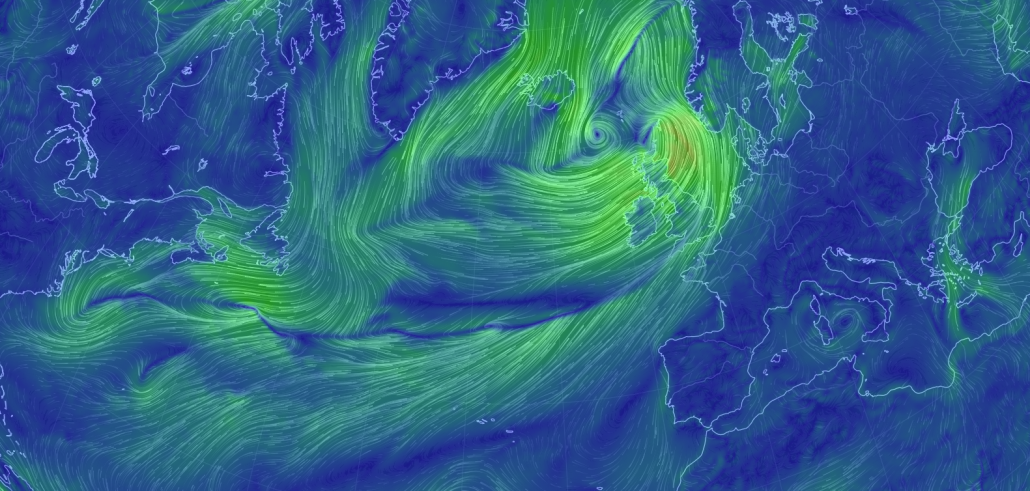
Storm Ali – Wind
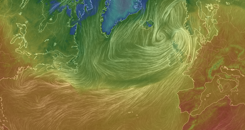
Storm Ali – Temperature
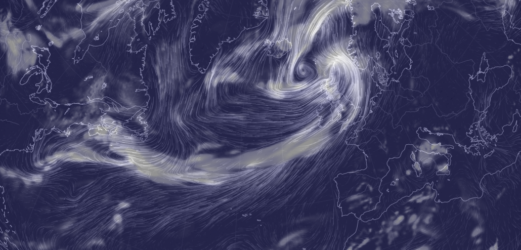
Storm Ali – Total Cloud Water
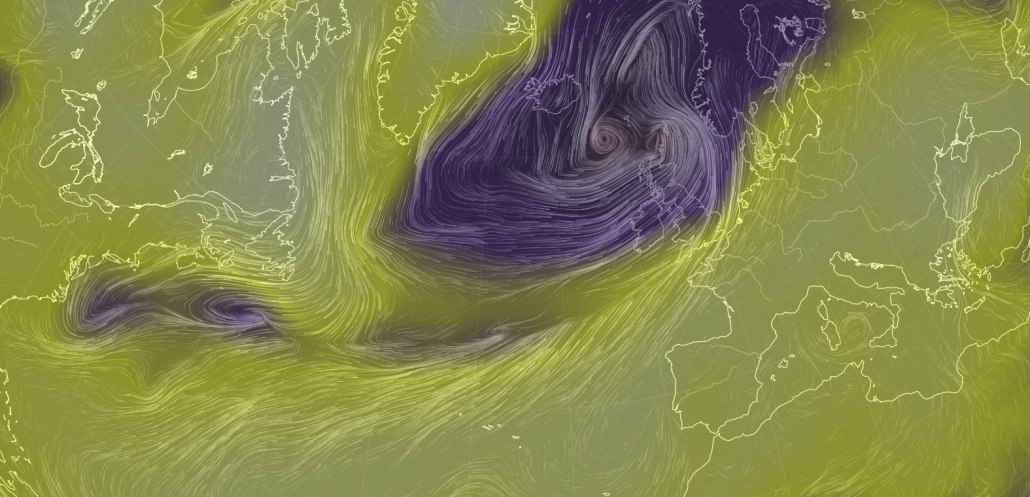
Storm Ali – Mean sea level pressure
Students could either use an electronic device to access images or images like those above could be provided to students to investigate the patterns and relationships between the different maps. From this, they could identify air masses, trends in surface pressure, weather fronts and their associated weather conditions. They could also be provided with a synoptic chart (like the one below) which could be annotated to bring the information together.
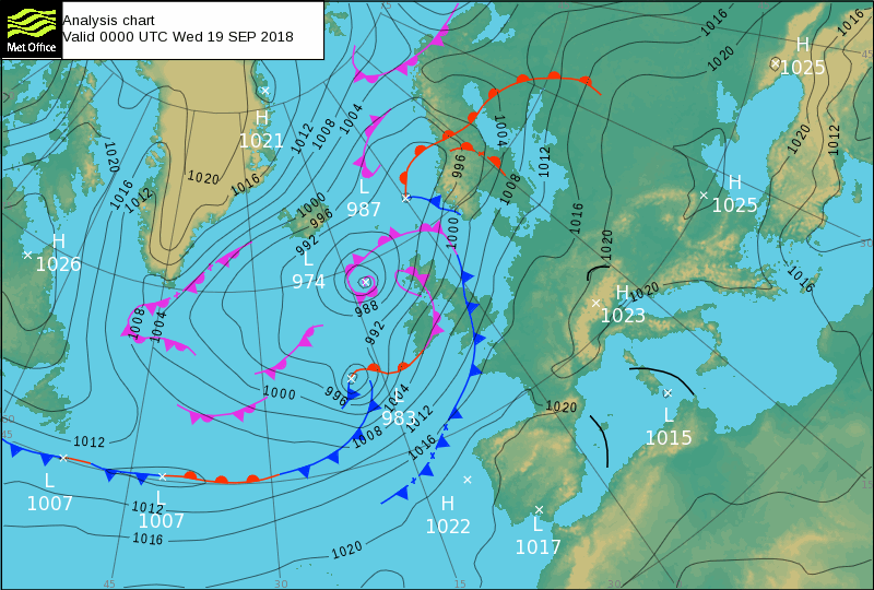
Synoptic chart for Storm Ali
Reason 3 – You can track weather over time – days / 3 hours
It is effortless to observe changes in weather and climate over time. By merely clicking Earth you can access control options to change the day of the data displayed. Within this, it is possible to see changes within the day. Just use the navigation icons under Control to do this.
Reason 4 – You can identify tropical storms
Students can use the website to identify and track tropical storms. They can work out differences between depressions and tropical storms using the different overlays.
It’s also easy to create a video showing changes over time. Below is a screen recording showing the path followed by Hurricane Florence across the Atlantic Ocean. An app to record the screen of a computer recorded the video while clicking through a series of dates.
Reason 5 – It’s up to date
Data is up to date. Most information is updated every 3 hours.
Reason 6 – Projections up to 4 days in the future
Data projections are available for up to four days in advance. This can be used to encourage students to check and challenge projected changes in data. For example, students could investigate the expected pathway of a tropical storm and evaluate the protections based on the data available.
Reason 7 – Ocean currents – fetch of a wave
Ocean current overlays are available which can be used to show the fetch of a wave. When combined with tide height data this is an interesting way of comparing tides between places and how these are affected by prevailing wind, wind speed and wave fetch.
Reason 8 – Aerosols
Aerosols are also available as overlays. These can be used to examine sources of air pollution and how the prevailing wind determines pollution forecasts. Remember the red sun associated with Storm Ophelia caused by Saharan sand? What better way to demonstrate this?
Reason 9 – Present maps different projections
Maps are presented in a range of projections. These are useful when teaching map skills.
Reason 10 – Works on virtually any device
Earth.nullschool works on almost any device. Students can access on mobile phones, tablets, laptops and desktops. This makes it a very inclusive resource.
If you’re not using Earth.nullschool yet head over to the website and have an explore. But beware, it’s quite addictive!
Got a suggestion to add to our ten reasons you need earth.nullschool in your geography classroom? Please leave a comment below.
Anthony Bennett
Leave a Reply
Want to join the discussion?Feel free to contribute!
Leave a Reply

Teaching the global atmospheric circulation and oceanic circulation. See where the ITCZ is at the moment, visualise the Gulf stream etc.